New Aug 11 Tornadoes and Downbursts in ON
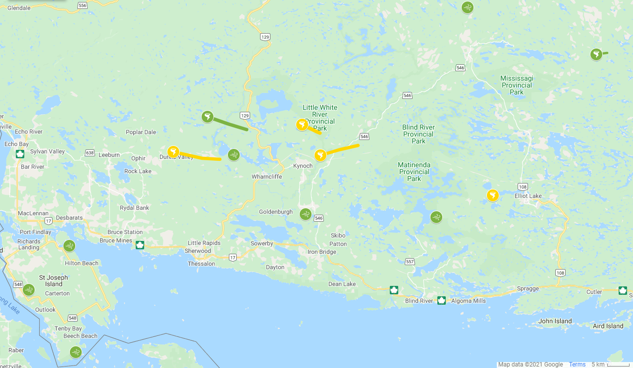
A storm cluster that affected areas between the Soo and Elliot Lake on Aug 11 left complex areas of damage behind. Aircraft aerial imagery was obtained and thoroughly analyzed. Planet hi-res satellite imagery was also analyzed. Event updates and descriptions of new and existing events are provided below. A map showing the locations of all Aug 11 events is also provided (green = EF1, yellow = EF2). Thanks to Jerry Shields and Ellen Fabbro for contributing to the survey data for the Harmony - Milford Haven downburst!
- Event Name: Harmony - Milford Haven, ON
- Date: August 11, 2021
- Time: 4:05 PM EDT (2005Z)
- Final Classification: Downburst
- Final EF-Scale Rating: EF1
- EF-Scale Damage Indicator / Degree of Damage: C-T/DOD-5
- Location of worst damage: 46.2058N, 84.0354W
- Description: Tree and structural damage was reported on St. Joseph Island after a storm passed through the area. A witness in the Harmony area captured a short video of a vortex attached to cloud base (the surface was obscured) while the storm was over Michigan. Satellite imagery review revealed tornado damage track in that area, however it appears the tornado dissipated before the storm reached Canadian soil. Satellite imagery review over St. Joseph Island revealed a wide swath of intermittent visible tree damage consistent with a downburst event extending from Harmony area to the Milford Haven area. Aerial imagery in Harmony was collect on September 27, 2021 and treefall analysis confirmed a downburst, assessed as EF1, with estimated max. wind speed of 170 km/h. Additional microburst events have been identified at Gawas Bay and Whiskey Bay.
- Event Name: Gawas Bay, ON
- Date: August 11, 2021
- Time: 4:15 PM EDT (2015Z)
- Final Classification: Microburst
- Final EF-Scale Rating: EF1
- EF-Scale Damage Indicator / Degree of Damage: C-T/DOD-5
- Location of worst damage: 46.2902N, 83.9235W
- Description: Tree and structural damage was reported at Gawas Bay, north of Hilton Beach, after a storm passed through the area. Satellite imagery review revealed microburst damage in the area. Damage assessed as EF1, with an estimated max. wind speed of 145 km/h.
- Event Name: Whiskey Bay (Jocelyn), ON
- Date: August 11, 2021
- Time: 4:20 PM EDT (2020Z)
- Final Classification: Microburst
- Final EF-Scale Rating: EF1
- EF-Scale Damage Indicator / Degree of Damage: C-T/DOD-5
- Location of worst damage: 46.0855N, 83.9059W
- Description: Tree damage was reported near Whiskey Bay, south of Beech Beach, after a storm passed through the area. Satellite imagery review revealed microburst damage in the area. Damage assessed as EF1, with an estimated max. wind speed of 145 km/h.
- Event Name: Dunns Valley, ON
- Date: August 11, 2021
- Time: 4:30 PM EDT (2030Z)
- Final Classification: Tornado
- Preliminary Rating: EF2
- Start of damage track: 46.4698N, 83.6352W
- Description: Tree damage was reported in the Dunns Valley area eastward toward Wharncliffe following a storm passing through. Satellite imagery review revealed a tornado track and suspected concurrent downburst damage through the heavily treed area. Aerial imagery was collected on September 27, 2021 and confirmed a tornado damage track and concurrent downburst damage. Preliminary assessment of the tornado damage is EF2, with an estimated max. wind speed of 190 km/h, track length of 9.93 km and max. path width of 820 m. Tornado motion was from the W (approx. 280 degrees). Preliminary assessment of the concurrent downburst damage is EF1, with an estimated max. speed of 145 km/h.
- Event Name: Basswood Lake, ON
- Date: August 11, 2021
- Time: 4:35 PM EDT (2035Z)
- Final Classification: Downburst
- Final EF-Scale Rating: EF1
- EF-Scale Damage Indicator / Degree of Damage: C-T/DOD-5
- Location of worst damage: 46.3511N, 83.2684W
- Description: Satellite imagery review of a storm track of interest revealed tree damage in the Basswood Lake area. Aerial imagery was collected on September 27, 2021 and a downburst event was confirmed. Damage assessed as EF1, with an estimated max. wind speed of 170 km/h.
- Event Name: Toobee Lake, ON
- Date: August 11, 2021
- Time: 5:10 PM EDT (2110Z)
- Final Classification: Downburst
- Final EF-Scale Rating: EF1
- EF-Scale Damage Indicator / Degree of Damage: C-T/DOD-5
- Location of worst damage: 46.7457N, 82.8189W
- Description: Satellite imagery review of a storm track of interest revealed tree damage near Toobee Lake consistent with a downburst event. Damage assessed as EF1 downburst, with an estimated max. wind speed of 145 km/h.
- Event Name: Elliot Lake, ON
- Date: August 11, 2021
- Time: 5:10 PM EDT (2110Z)
- Final Classification: Tornado (Over Land)
- Final EF-Scale Rating: EF2
- EF-Scale Damage Indicator / Degree of Damage: C-T/DOD-6
- Start of damage track: 46.3870N, 82.7493W
- End of damage of track: 46.3874N, 82.7449W
- Location of worst damage: 46.3879N, 82.7430W
- Description: Tree damage was reported in the Elliot Lake area following a storm passing through. Satellite imagery review revealed a short damage track leading up to the western shore of Elliot Lake, and drone imagery captured by private citizens on behalf of NTP provided confirmation of tornado damage. Damage assessed as EF2 tornado, with an estimated max. wind speed of 190 km/h, track length of 0.50 km and max. path width of 340 m. Tornado motion was from the W (approx. 260 degrees).
- Event Name: Campover Lake, ON
- Date: August 11, 2021
- Time: 5:30 PM EDT (2130Z)
- Final Classification: Tornado (Over Land)
- Final EF-Scale Rating: EF1
- EF-Scale Damage Indicator / Degree of Damage: C-T/DOD-5
- Start of damage track: 46.6557N, 82.4617W
- End of damage of track: 46.6586N, 82.4313W
- Location of worst damage: 46.6587N, 82.4326W
- Description: Satellite imagery review of a storm track revealed a tornado damage path through a forested area. Damage assessed as EF1, with an estimated max. wind speed of 145 km/h, track length of 2.65 km and max. path width of 160 m. Tornado motion was from the W (approx. 260 degrees).