Prairie Tornado Update (#4)
It's been a fairly busy tornado season on the Prairies, particularly Alberta and Saskatchewan. So much so that a fourth multi-event NTP update is needed! This one covers events from June 10th to August 4th in Alberta and Saskatchewan that required extra work to get right. Many of these are new events.
The detailed summaries are provided below.
Event Name: Furness, SK
Date: June 10, 2022
Start Time: 12:40 PM CST (1840 UTC)
Final Classification: Tornado (Over Land)
Final EF-Scale Rating: EF0-Default
Estimated tornado location: 53.15N, 109.92W
Description: Witness captured video of a brief tornado northeast of Furness. As no damage was reported and satellite imagery review revealed no visible damage, the EF-Scale assessment is default EF0. Information available insufficient to accurately estimate track length, max. path width and tornado motion.
Event Name: Arbury, SK
Date: June 29, 2022
Start Time: 6:15 PM CST (0015 UTC)
Final Classification: Tornado (Over Land)
Final EF-Scale Rating: EF0-Default
Start of crop damage: 51.1122N, 104.3545W
End of crop damage: 51.0878N, 104.3211W
Description: Witness in the Cupar area captured photos of a tornado near Arbury. Satellite imagery review of the area revealed a 3.58 km long track of crop damage (max. path width of 120 m). Tornado motion was from the NW (approx 320 degrees). As no official damage indicators appear to have been impacted, EF-Scale damage assessment is EF0-Default. The same parent supercell earlier produced four tornadoes near Cymric and Serath, SK.
Event Name: Neutral Hills, AB
Date: July 5, 2022
Start Time: 4:44 PM MDT (2244 UTC)
Final Classification: Tornado (Over Land)
Final EF-Scale Rating: EF0-Default
Estimated tornado location: 52.21N, 110.76W
Description: Witness captured video of a brief tornado over fields east of Neutral Hills. As no damage was reported and satellite imagery review revealed no visible damage, the EF-Scale assessment is default EF0. Information available insufficient to accurately estimate track length, max. path width and tornado motion.
Event Name: Monitor, AB
Date: July 5, 2022
Start Time: 4:44 PM MDT (2244 UTC)
Final Classification: Tornado (Over Land)
Final EF-Scale Rating: EF0-Default
Estimated tornado location: 51.94N, 110.59W
Description: Witnesses in the Consort area captured photos of a brief tornado over fields near Monitor. As no damage was reported and satellite imagery review revealed no visible damage, the EF-Scale assessment is default EF0. Information available insufficient to accurately estimate track length, max. path width and tornado motion.
Event Name: Glidden, SK
Date: July 5, 2022
Start Time: 5:25 PM CST (2325 UTC)
Final Classification: Tornado (Over Land)
Final EF-Scale Rating: EF0-Default
Estimated tornado location: 51.18N, 109.19W
Description: Witnesses captured video and photos of a tornado over fields south of Glidden. As no damage was reported and satellite imagery review revealed no visible damage, the EF-Scale assessment is default EF0. Information available insufficient to accurately estimate track length, max. path width and tornado motion.
Event Name: Smiley, SK
Date: July 5, 2022
Start Time: 6:30 PM CST (0030 UTC)
Final Classification: Tornado (Over Land)
Final EF-Scale Rating: EF0-Default
Estimated tornado location: 51.60N, 109.33W
Description: Witness captured video of a tornado over fields southeast of Smiley. As no damage was reported and satellite imagery review revealed no visible damage, the EF-Scale assessment is default EF0. Information available insufficient to accurately estimate track length, max. path width and tornado motion.
Event Name: Radville, SK
Date: July 17, 2022
Start Time: 4:50 PM CST (2250 UTC)
Final Classification: Tornado (Over Land)
Final EF-Scale Rating: EF0-Default
Estimated tornado location: 49.37N, 104.47W
Description: Witness captured photos of a tornado southwest of Radville. As no damage was reported and satellite imagery review revealed no visible damage, the EF-Scale assessment is default EF0. Information available insufficient to accurately estimate track length, max. path width and tornado motion.
Event Name: Little Island Lake, SK
Date: August 4, 2022
Start Time: 6:20 PM CST (0020 UTC)
Final Classification: Tornado (Over Land)
Final EF-Scale Rating: EF0-Default
Estimated tornado location: 53.53N, 107.39W
Description: Witness in the Witchekan area captured a photo of a tornado near Little Island Lake. No injuries were reported. As no damage was reported and satellite imagery review revealed no visible damage, the EF-Scale assessment is default EF0. Information available insufficient to accurately estimate track length, max. path width and tornado motion.
Event Name: Erinferry, SK
Date: August 4, 2022
Start Time: 6:53 PM CST (0053 UTC)
Final Classification: Tornado (Over Land)
Final EF-Scale Rating: EF2
EF-Scale Damage Indicator / Degree of Damage: C-T/DOD-6
Start of damage track: 53.6378N, 106.9858W
End of damage of track: 53.6425N, 106.9825W
Location of worst damage: 53.6395N, 106.9842W
Description: Tree and power pole damage was reported southeast of Erinferry after a storm passed through the area. Drone footage captured by a resident revealed a short track of convergent treefall in a forested area and subsequent satellite imagery review revealed the tornado damage path along with surrounding downburst damage. Tornado damage assessed as EF2, with an estimated max. wind speed of 190 km/h, track length of 600 m and max. path width of 270 m. Tornado motion was from the SSW (approx. 205 degrees). The concurrent downburst damage was assessed as EF1, with an estimated max. wind speed of 145 km/h. Start time is radar estimated. The same parent supercell earlier produced an EF0-Default tornado near Little Island Lake (Witchekan), SK.
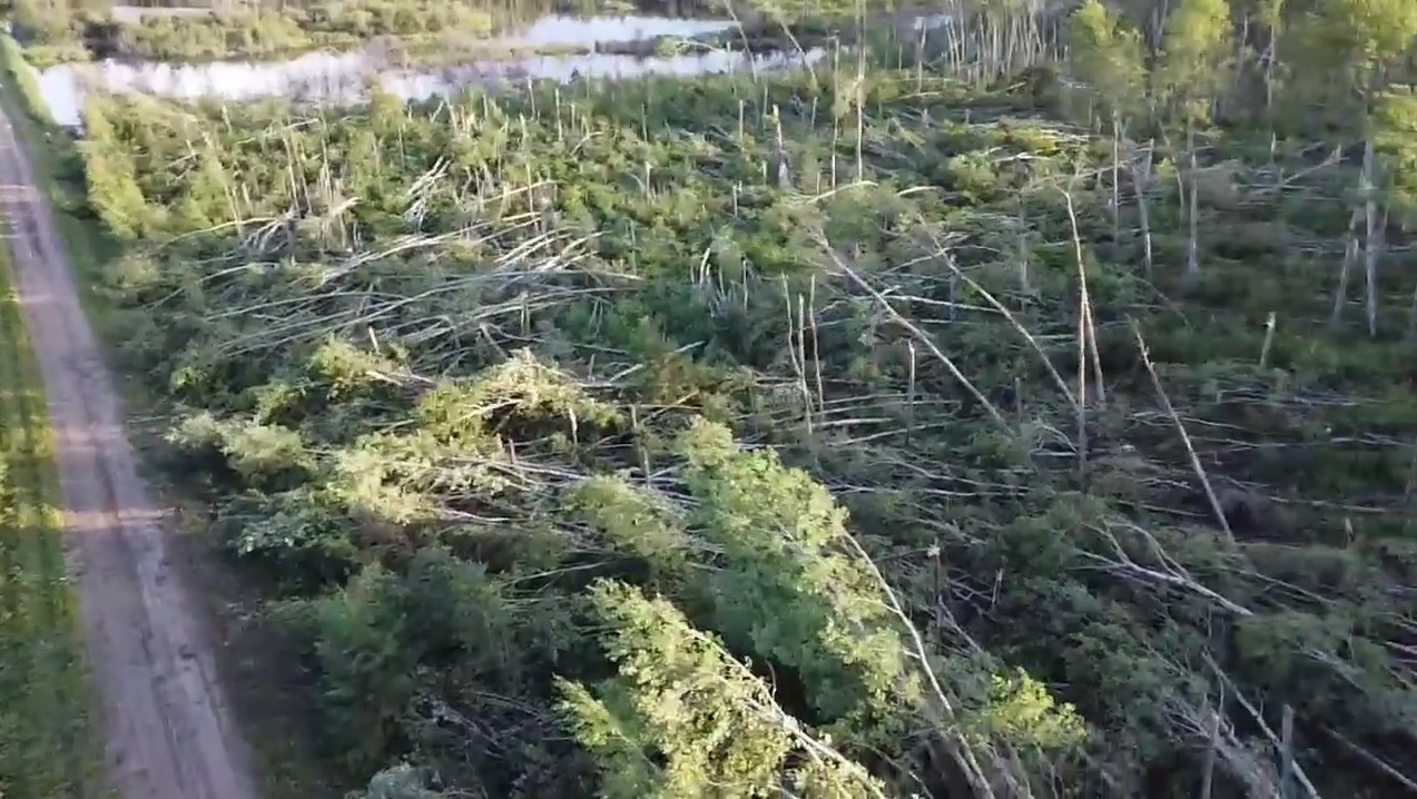
Frame from drone video shared on Facebook by J. Mclean showing rotation / convergence pattern in treefall, looking SSE.
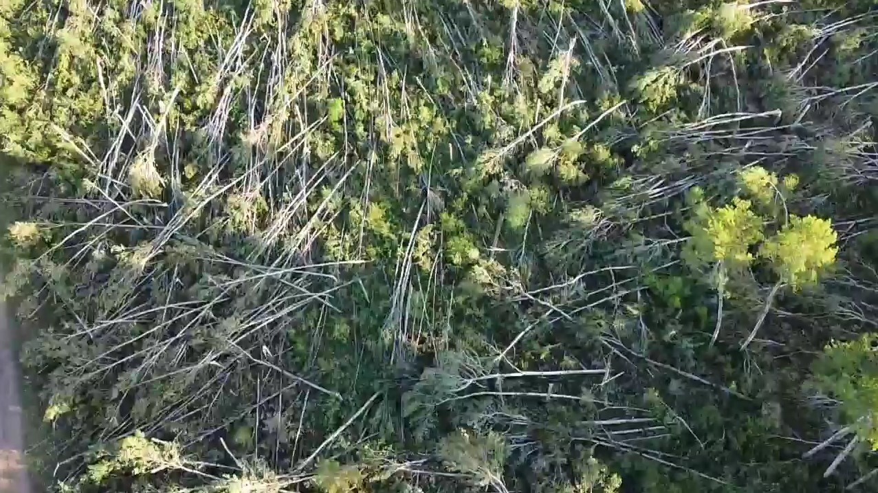
Frame from drone video shared on Facebook by J. Mclean showing strong convergence pattern in treefall, looking down with top of image toward S.
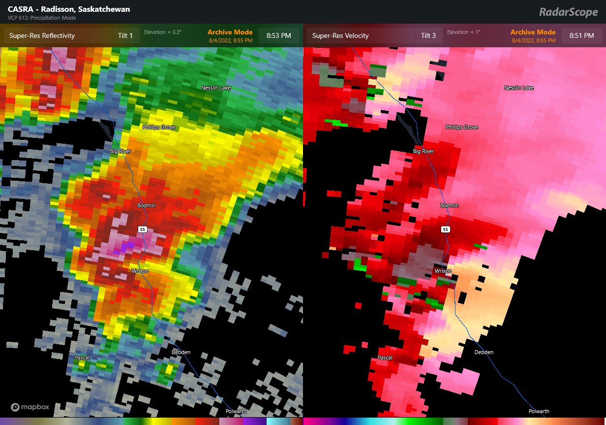
Radar image showing the intense supercell thunderstorm that produced the Erinferry EF2 tornado. At left, reflectivity showing a rain-filled hook area. At right, radial velocity showing a rotation couplet just south of Wrixon at Erinferry.