Uxbridge ON EF2 tornado UPDATE
NTP has already confirmed that an EF2 tornado was the cause of the significant damage at Uxbridge, ON with the derecho of May 21st. Further analysis of ground survey data, aerial images and satellite data has resulted in the length of the Uxbridge EF2 tornado being extended from just over 4 km to 16 km. The preliminary data for this event are provided below. Note that there is wind-related damage further to the ENE that may be classified as a separate tornado after further investigation.
Here is an updated event summary:
- Event Name: Uxbridge, ON
- Date: May 21, 2022
- Time: 1:15 PM EDT (1715 UTC)
- Final Classification: Tornado (Over Land)
- Final EF-Scale Rating: EF2
- EF-Scale Damage Indicator / Degree of Damage: ACT/DOD-4
- Start of damage track: 44.1034N, 79.1465W
- End of damage of track: 44.1388N, 78.9538W
- Location of worst damage: 44.1098N, 79.1244W
- Description: Structural and tree damage reported in Uxbridge after a storm passed through the area. Two apartment buildings, several homes and business buildings suffered damage. Two vehicles were also flipped and/or rolled several feet. Numerous trees were snapped and uprooted. No major injuries requiring treatment have been reported. An NTP ground and drone survey was completed on May 22, 2022 in Uxbridge and eastward to Lake Scugog. Satellite imagery review confirmed intermittent weak tree damage visible along the NTP survey route. Damage assessed as EF2 tornado, with an estimated max. wind speed of 195 km/h, track length of 16.0 km and max path width of 260 m. Motion was from the WSW (approx 255 degrees), with the tornado passing just south of the Greenbank-Uxbridge-Port Perry Airfield.
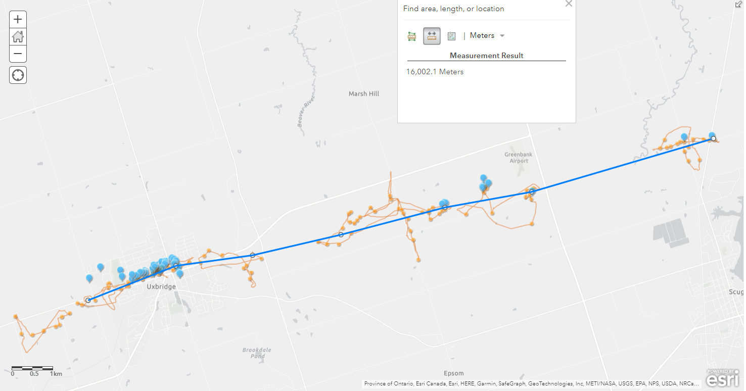
NTP investigation map for the Uxbridge tornado - the blue line indicates the path of the tornado, blue points are where ground photos were taken, orange lines are drone flight paths and orange points are where drone photos were taken.