Five tornadoes with June 13 storms in QC
NTP investigation has confirmed five tornadoes that occurred with the storms on June 13 in western QC. Three of the tornadoes caused EF2 tree damage while two others caused EF1 damage to trees. The tornado damage paths were found via analysis of high-resolution satellite imagery along radar-based storm tracks. It took about a week for satellite imagery to become available having enough cloud-free areas to fully view the affected areas of forest. Additional satellite imagery analysis may yield additional tornadoes.
The event summaries for these five tornadoes are provided below, along with a map and some of the satellite imagery used to confirm the tornadoes. The tornadoes can also be plotted using the NTP Dashboard here.
This brings the number of documented tornadoes in Quebec so far this season to six.
====
Event Name: Lac Nodier (Témiscamingue), QC
Date: June 13, 2024
Start Time: 5:30 PM EDT (2130 UTC)
Final Classification: Tornado (over land)
Final EF-Scale Rating: EF2
EF-Scale Damage Indicator / Degree of Damage: C-T/DOD-6
Start of damage track: 47.6755N, 78.3918W
End of damage track: 47.6783N, 78.2279W
Location of worst damage: 47.6773N, 78.2649W
Description: Satellite imagery review of a storm track of interest revealed tornado damage in forested areas near Lac Nodier (Témiscamingue). Tornado damage is assessed as EF2, with an estimated max. wind speed of 190 km/h, track length of 12.4 km and max. path width of 520 m. Tornado motion was from the W (approx. 270 degrees). Start time is radar estimated.
Event Name: Pointe Albert (Reservoir Decelles), QC
Date: June 13, 2024
Start Time: 5:45 PM EDT (2145 UTC)
Final Classification: Tornado (over land)
Final EF-Scale Rating: EF2
EF-Scale Damage Indicator / Degree of Damage: C-T/DOD-6
Start of damage track: 47.6976N, 78.1582W
End of damage track: 47.7231N, 77.9461W
Location of worst damage: 47.7016N, 78.1374W
Description: Satellite imagery review of a storm track of interest revealed tornado damage in forested areas near Pointe Albert (Reservoir Decelles). Tornado damage is assessed as EF2, with an estimated max. wind speed of 190 km/h, track length of 16.7 km and max. path width of 770 m. Tornado motion was from the W (approx. 260 degrees). Start time is radar estimated.
Event Name: Lac Bend (Val-d'Or), QC
Date: June 13, 2024
Start Time: 6:15 PM EDT (2215 UTC)
Final Classification: Tornado (over land)
Final EF-Scale Rating: EF2
EF-Scale Damage Indicator / Degree of Damage: C-T/DOD-6
Start of damage track: 47.7197N, 77.7508W
End of damage track: 47.7542N, 77.5075W
Location of worst damage: 47.7222N, 77.7188W
Description: Satellite imagery review of a storm track of interest revealed tornado damage in forested areas near Lac Bend (Val-d'Or). Tornado damage is assessed as EF2, with an estimated max. wind speed of 190 km/h, track length of 18.7 km and max. path width of 990 m. Tornado motion was from the W (approx. 260 degrees). Start time is radar estimated.
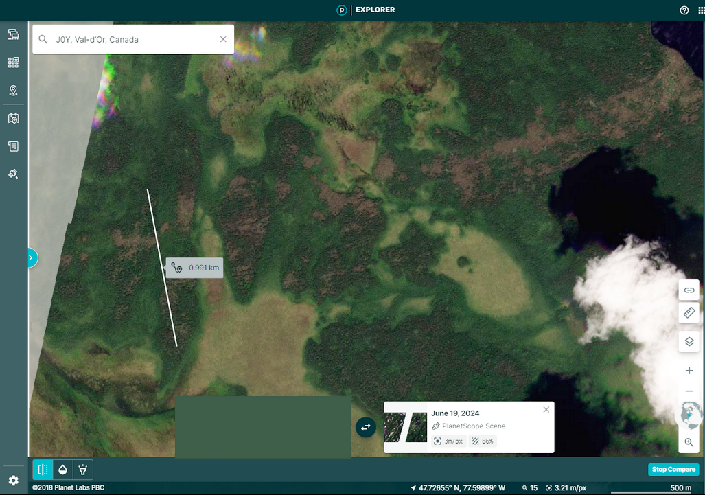
Event Name: Lac Kwîkwîcî (Val-d'Or), QC
Date: June 13, 2024
Start Time: 6:15 PM EDT (2215 UTC)
Final Classification: Tornado (over land)
Final EF-Scale Rating: EF1
EF-Scale Damage Indicator / Degree of Damage: C-T/DOD-5
Start of damage track: 47.9190N, 77.0467W
End of damage track: 47.9174N, 76.9932W
Location of worst damage: 47.9168N, 77.0274W
Description: Satellite imagery review of a storm track of interest revealed tornado damage in forested areas near Lac Kwîkwîcî (Val-d'Or). Tornado damage is assessed as EF1, with an estimated max. wind speed of 145 km/h, track length of 4.03 km and max. path width of 330 m. Tornado motion was from the W (approx. 270 degrees). Start time is radar estimated.
Event Name: Lac Darbit (La Vallée-de-l'Or), QC
Date: June 13, 2024
Start Time: 6:45 PM EDT (2245 UTC)
Final Classification: Tornado (over land)
Final EF-Scale Rating: EF1
EF-Scale Damage Indicator / Degree of Damage: C-T/DOD-5
Start of damage track: 47.9390N, 76.6596W
End of damage track: 47.9614N, 76.6118W
Location of worst damage: 47.9403N, 76.6579W
Description: Satellite imagery review of a storm track of interest revealed tornado damage in forested areas near Lac Darbit (La Vallée-de-l'Or). Tornado damage is assessed as EF1, with an estimated max. wind speed of 145 km/h, track length of 4.37 km and max. path width of 200 m. Tornado motion was from the SW (approx. 235 degrees). Start time is radar estimated.
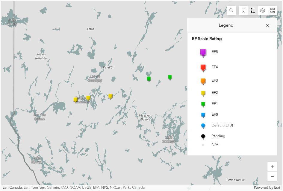
Map showing the locations for the five tornadoes in western Quebec on June 13.
WSW to ENE path of tree damage with a max width of 990 m associated with the Lac Bend (Val-d'Or), QC EF2 tornado.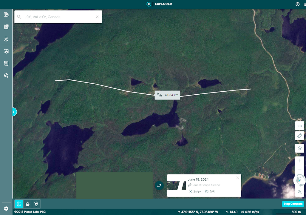
W to E path of intermittent tree damage with a length of 4.03 km associated with the Lac Kwîkwîcî (Val-d'Or), QC EF1 tornado.