Five tornadoes with June 3 storms in AB
An NTP investigation, including a thorough ground / drone survey, has confirmed that 5 separate tornadoes were spawned by afternoon storms on June 3 in AB, well southeast of Edmonton. Three of the tornadoes in the Edberg area caused damage rated at EF0, while two others caused no damage and were assigned an EF0-Default rating. No injuries were reported.
Below are the event summaries for each tornado and a map of the tornado locations. Selected survey images for some sites are also shown. Tornadoes can be plotted using the NTP Dashboard here.
====
Event Name: Edberg (1), AB
Date: June 3, 2024
Start Time: 2:38 PM MDT (2038Z)
Final Classification: Tornado (Over Land)
Final EF-Scale Rating: EF0
EF-Scale Damage Indicator / Degree of Damage: C-T/DOD-3
Start of damage track: 52.7684N, 112.8374W
End of damage track: 52.7699N, 112.8402W
Location of worst damage: 52.7696N, 112.8402W
Description: Witnesses captured video and photos of a tornado southwest of Edberg. An NTP ground and drone survey was completed on June 4, 2024, documenting a short damage track through cropland as well as weak tree damage. Satellite imagery review did not reveal any visible damage. Damage assessed as EF0 tornado, with an estimated max. wind speed of 115 km/h, track length of 250 m and max. path width of 30 m. Tornado motion was from the SE (approx. 130 degrees). Start time is based on witness video.
Event Name: Edberg (2), AB
Date: June 3, 2024
Start Time: 2:52 PM MDT (2052Z)
Final Classification: Tornado (Over Land)
Final EF-Scale Rating: EF0-default
Estimated tornado location: 52.77N, 112.76W
Description: Witness captured drone video of a brief tornado southeast of Edberg. An NTP survey team searched the area for signs of damage on June 5, 2024 but was unable to find any evidence of tornado damage. Event assessed as EF0-default tornado. Satellite imagery review is pending. Start time is based on witness video.
Event Name: Edberg (3), AB
Date: June 3, 2024
Start Time: 2:53 PM MDT (2053Z)
Final Classification: Tornado (Over Land)
Final EF-Scale Rating: EF0
EF-Scale Damage Indicator / Degree of Damage: C-T/DOD-2
Start of damage track: 52.7556N, 112.6944W
End of damage track: 52.7589N, 112.6966W
Location of worst damage: 52.7570N, 112.6957W
Description: Witness captured drone video of a tornado southeast of Edberg. An NTP ground and drone survey was completed on June 4, 2024, documenting weak tree damage. Damage assessed as EF0 tornado, with an estimated max. wind speed of 90 km/h, track length of 400 m and max. path width of 40 m. Tornado motion was from the SSE (approx. 160 degrees). Start time is based on witness video. Satellite imagery review is pending.
Event Name: Edberg (4), AB
Date: June 3, 2024
Start Time: 2:56 PM MDT (2056Z)
Final Classification: Tornado (Over Land)
Final EF-Scale Rating: EF0
EF-Scale Damage Indicator / Degree of Damage: FR12/DOD-4
Start of damage track: 52.7852N, 112.7725W
End of damage track: 52.7907N, 112.8100W
Location of worst damage: 52.7900N, 112.7865W
Description: Witnesses captured video and photos of a tornado at Edberg. House and tree damage was reported at property in the area. An NTP ground and drone survey was completed on June 4, 2024, documenting the reported damage and additional crop and tree damage. Satellite imagery review also revealed visible damage to crops along the path. Damage assessed as EF0 tornado, with an estimated max. wind speed of 130 km/h, track length of 2.67 km and max. path width of 160 m. Tornado motion was from the ESE (approx. 105 degrees). Start time is based on witness video.
Event Name: Gadsby, AB
Date: June 3, 2024
Start Time: 4:45 PM MDT (2245Z)
Final Classification: Tornado (Over Land)
Final EF-Scale Rating: EF0-default
Estimated tornado location: 52.26N, 112.26W
Description: Witness captured photos of tornado southeast of Gadsby. An NTP survey team searched the area for signs of damage on June 5, 2024 but was unable to find any evidence of tornado damage. Event assessed as EF0-default tornado. Satellite imagery review is pending. Start time is based on witness report.
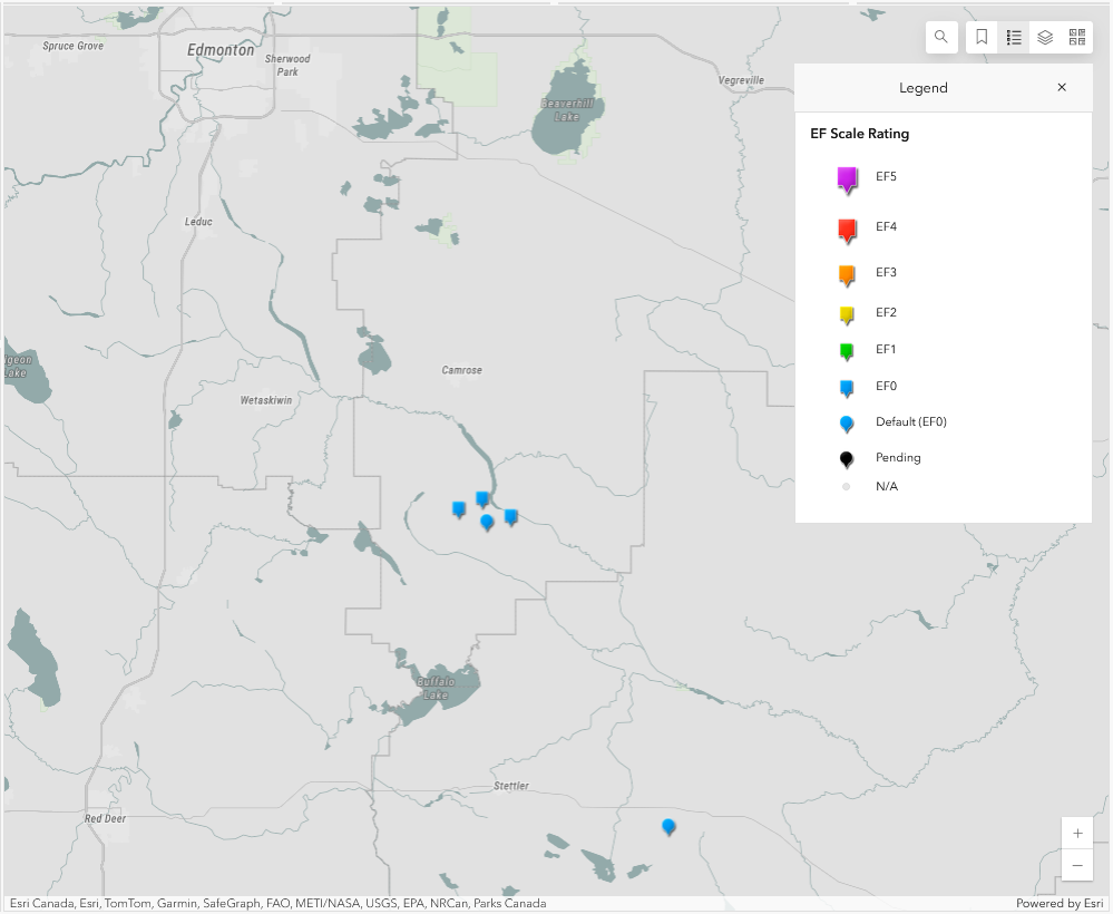
Map showing the locations of the five tornadoes southeast of Edmonton.
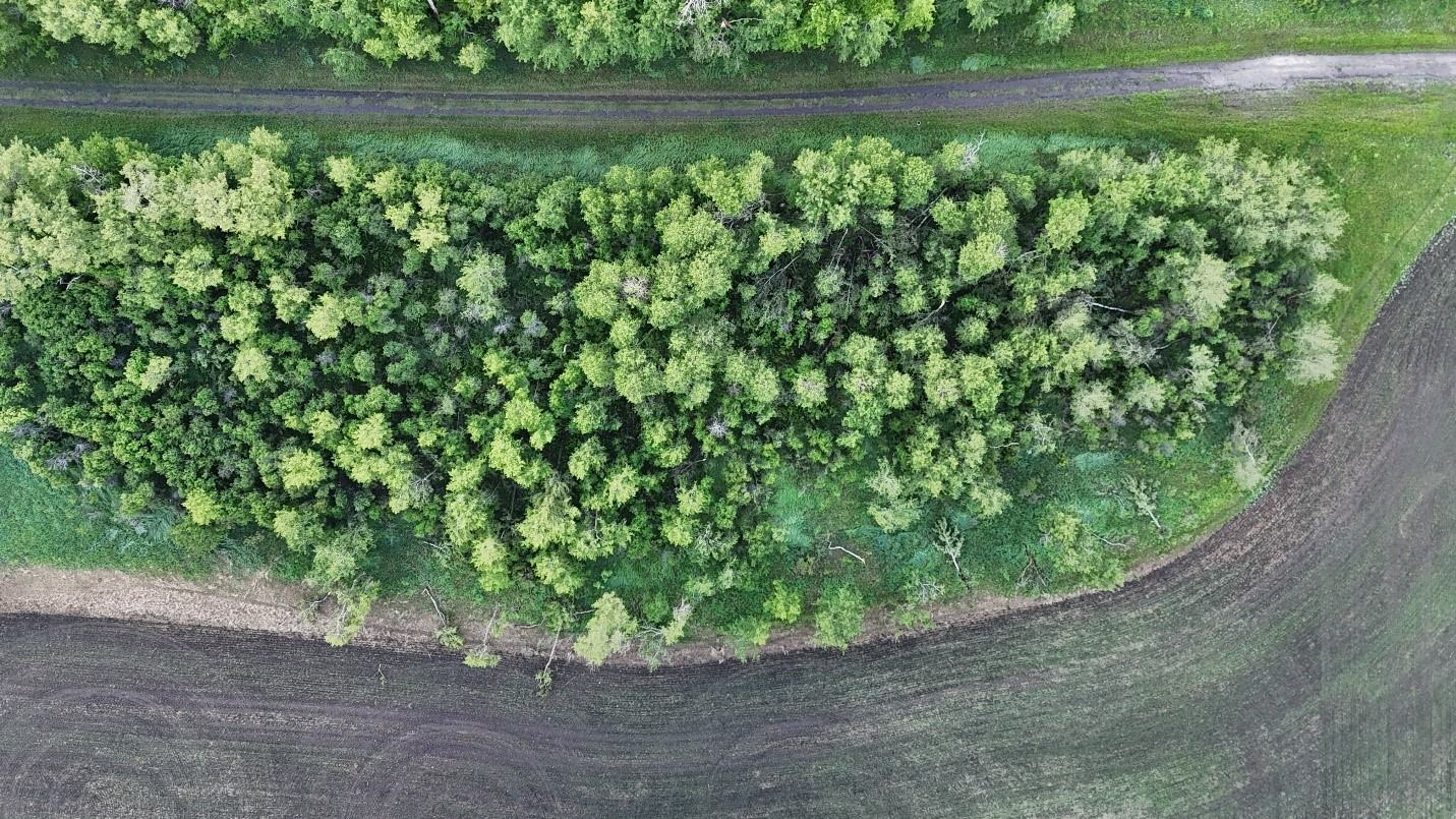
Edberg (1) tornado. Nadir drone photo of C-T/DOD-3 tree damage with convergent tree fall directions.
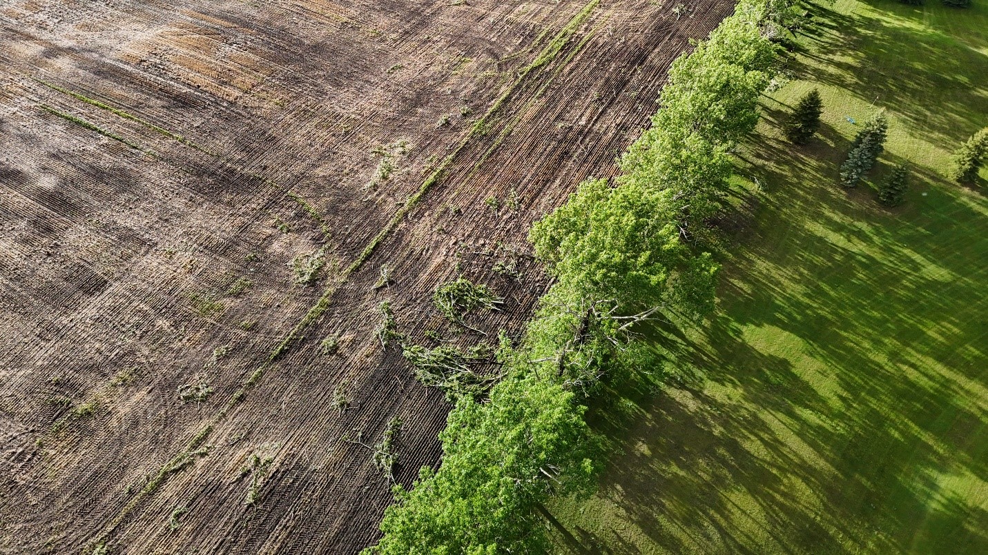
Edberg (2) tornado. Oblique drone photo showing C-T/DOD-2 on both sides along tree line to the west of Cherry Lane B&B. Photo pointing NW.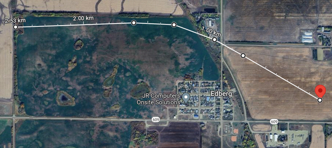
Edberg (4) tornado. Map showing estimated track of the tornado with the start point designated by the red pin. No damage was found to the west of the tree line.
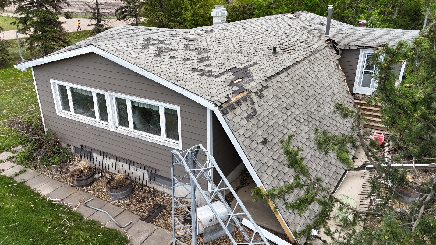
Edberg (4) tornado. Drone photo of worst damage at 52.7900 N, 112.7865 W. Collapse of covered deck/porch along with shattered windows and bent metal antenna.
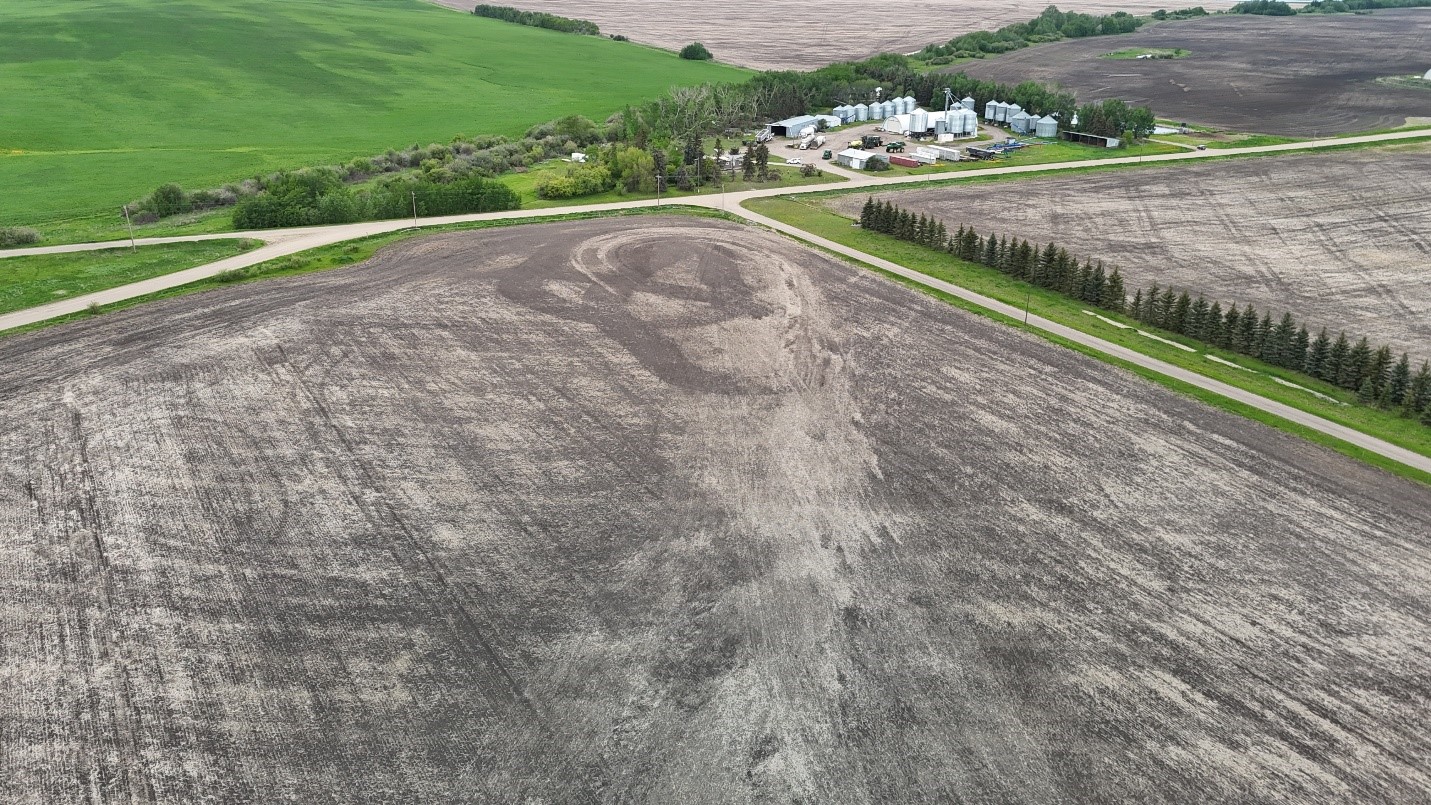
Edberg (4) tornado. Drone photo showing path of tornado in field leading up to house with downed trees behind it (photo facing NW).