Six tornadoes in SK/MB on June 12
NTP investigation has concluded that six tornadoes occurred in SK and MB on June 12. The first tornado hit Salcoats in southeast SK early in the afternoon, while a further five tornadoes developed between Rivers and St. Alphonse in southweste MB during the late afternoon and early evening. The EF scale ratings were assessed at between EF0-Default (no damage) to EF1. A downburst was also identified at the end of one of the tornadoes near Glenboro.
Note that these are the first tornadoes of the season for both SK and MB - a somewhat late start in those provinces.
Event summaries for each tornado and downburst are provided below, along with maps and damage photos. The events can also be plotted using the NTP Dashboard here.
====
Event Name: Saltcoats, SK
Date: June 12, 2024
Start Time: 1:51 PM CST (1951 UTC)
Final Classification: Tornado (Over Land)
Final EF-Scale Rating: EF0
EF-Scale Damage Indicator / Degree of Damage: C-T/DOD-3
Start of damage track: 51.0823N, 102.1237W
End of damage track: 51.0769N, 102.1226W
Location of worst damage: 51.0783N, 102.1227W
Description: Witnesses captured video and photos of a tornado northeast of Saltcoats. Damage to sheds and trees at a property was reported. No injuries were reported. An NTP ground and drone survey was completed on June 13, 2024, documenting the reported damage. Damage assessed as EF0 tornado, with an estimated max. wind speed of 115 km/h, track length of 630 m and max. path width of 290 m. Tornado motion was from the N (approx. 350 degrees). Start time is based on witness report. Satellite imagery review is pending.
Event Name: Rivers (1), MB
Date: June 12, 2024
Start Time: 4:27 PM CDT (2127 UTC)
Final Classification: Tornado (Over Land)
Final EF-Scale Rating: EF0-default
Estimated tornado location: 50.11N, 100.29W
Description: Witnesses captured video and photos of a tornado north of Rivers. No injuries were reported. An NTP ground and drone survey team visited the area on June 13, 2024, but found no signs of damage. As no damage was found and satellite imagery review revealed no visible damage, the EF-scale assessment is default EF0. Information available insufficient to accurately estimate track length, max. path width and tornado motion. Start time is based on witness reports.
Event Name: Rivers (2), MB
Date: June 12, 2024
Start Time: 4:35 PM CDT (2135 UTC)
Final Classification: Tornado (Over Land)
Final EF-Scale Rating: EF0
EF-Scale Damage Indicator / Degree of Damage: FR12/DOD-2
Start of damage track: 50.0656N, 100.1898W
End of damage track: 50.0282N, 100.1564W
Location of worst damage: 50.0465N, 100.1701W
Description: Witnesses captured video and photos of a tornado northeast of Rivers. Damage to trees, a shed and a boat lift was reported. No injuries were reported. An NTP ground and drone survey was completed on June 13-14, 2024, documenting the reported damage and minor roof damage to two homes. Damage assessed as EF0 tornado, with an estimated max. wind speed of 125 km/h, track length of 4.81 km and max. path width of 210 m. Tornado motion was from the NNW (approx. 330 degrees). Start time is based on witness reports. Satellite imagery review is pending.
Event Name: Glenboro (Spruce Woods PP), MB
Date: June 12, 2024
Start Time: 5:45 PM CDT (2245 UTC)
Final Classification: Tornado (Over Land)
Final EF-Scale Rating: EF1
EF-Scale Damage Indicator / Degree of Damage: C-T/DOD-5
Start of damage track: 49.6874N, 99.2864W
End of damage track: 49.6761N, 99.2406W
Location of worst damage: 49.6846N, 99.2756W
Description: Organized thunderstorms tracked through southwestern MB on June 12, including a supercell from Forrest to Glenboro. An NTP ground and drone survey team searched for signs of damage along the storm track on June 13, 2024 and discovered some tornado and downburst damage north of Glenboro in Spruce Woods Provincial Park. Satellite imagery review of the area revealed a longer narrow path of tornado damage in treed areas, and weak scattered damage at the end of the tornado track. Damage assessed as EF1 tornado, with an estimated max. wind speed of 145 km/h, track length of 3.62 km and max. path width of 340 m. Tornado motion was from the WNW (approx. 290 degrees). Start time is radar estimated. Downburst damage at the end of the tornado is assessed as EF0 (microburst), with an estimated max. wind speed of 115 km/h.
Event Name: Glenboro (Spruce Woods PP), MB
Date: June 12, 2024
Start Time: 5:48 PM CDT (2248 UTC)
Final Classification: Downburst (microburst)
Final EF-Scale Rating: EF0
EF-Scale Damage Indicator / Degree of Damage: C-T/DOD-3
Location of worst damage: 49.6708N, 99.2454W
Description: Organized thunderstorms tracked through southwestern MB on June 12, including a supercell from Forrest to Glenboro. An NTP ground and drone survey team searched for signs of damage along the storm track on June 13, 2024 and discovered some tornado and downburst damage north of Glenboro in Spruce Woods Provincial Park. Satellite imagery review of the area revealed a longer narrow path of tornado damage in treed areas, and weak scattered damage at the end of the tornado track. Downburst damage assessed as EF0 (microburst), with an estimated max. wind speed of 115 km/h. Start time is radar estimated. Tornado damage was assessed as EF1, with an estimated max. wind speed of 145 km/h.
Event Name: Saint Alphonse (1), MB
Date: June 12, 2024
Start Time: 6:08 PM CDT (2308 UTC)
Final Classification: Tornado (Over Land)
Final EF-Scale Rating: EF0-default
Estimated tornado location: 49.471N, 99.137W
Description: Witnesses captured video and photos of a brief tornado northwest of Saint Alphonse. No injuries were reported. An NTP ground and drone survey team searched for signs of damage on June 14-15, 2024, and did not discover any. As no damage was found and satellite imagery review revealed no visible damage, the EF-scale assessment is default EF0. Information available insufficient to accurately estimate track length (though a witness estimated the tornado traveled at least 0.5 km across open fields), max. path width and tornado motion. Start time is based on witness reports.
Event Name: Saint Alphonse (2), MB
Date: June 12, 2024
Start Time: 6:17 PM CDT (2317 UTC)
Final Classification: Tornado (Over Land)
Final EF-Scale Rating: EF1
EF-Scale Damage Indicator / Degree of Damage: SBO/DOD-8
Start of damage track: 49.4382N, 99.0554W
End of damage track: 49.3511N, 98.8297W
Location of worst damage: 49.4273N, 99.0330W
Description: Witnesses captured video and photos of a tornado that developed west of Saint Alphonse and tracked southeast to Swan Lake First Nation. Damage was reported at a farm property, where a machine shed was destroyed, grain bins damaged and nearby trees were snapped. A powwow arbour at Swan Lake was also damaged. No injuries were reported. An NTP ground and drone survey was completed on June 14-15, 2024, documenting the reported damage and additional damage to grain bins and trees. Satellite imagery review revealed some areas of visible tree damage along the tornado track. Damage assessed as EF1 tornado, with an estimated max. wind speed of 150 km/h, track length of 19.0 km and max. path width of 1.05 km. Tornado motion was from the WNW (approx. 300 degrees). Start time is based on witness reports.
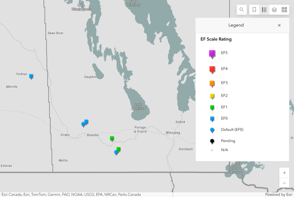
Map showing the locations of the six tornadoes that occurred on June 12. The downburst was considered 'concurrent' with the Glenboro tornado so is not plotted on the dashboard map.
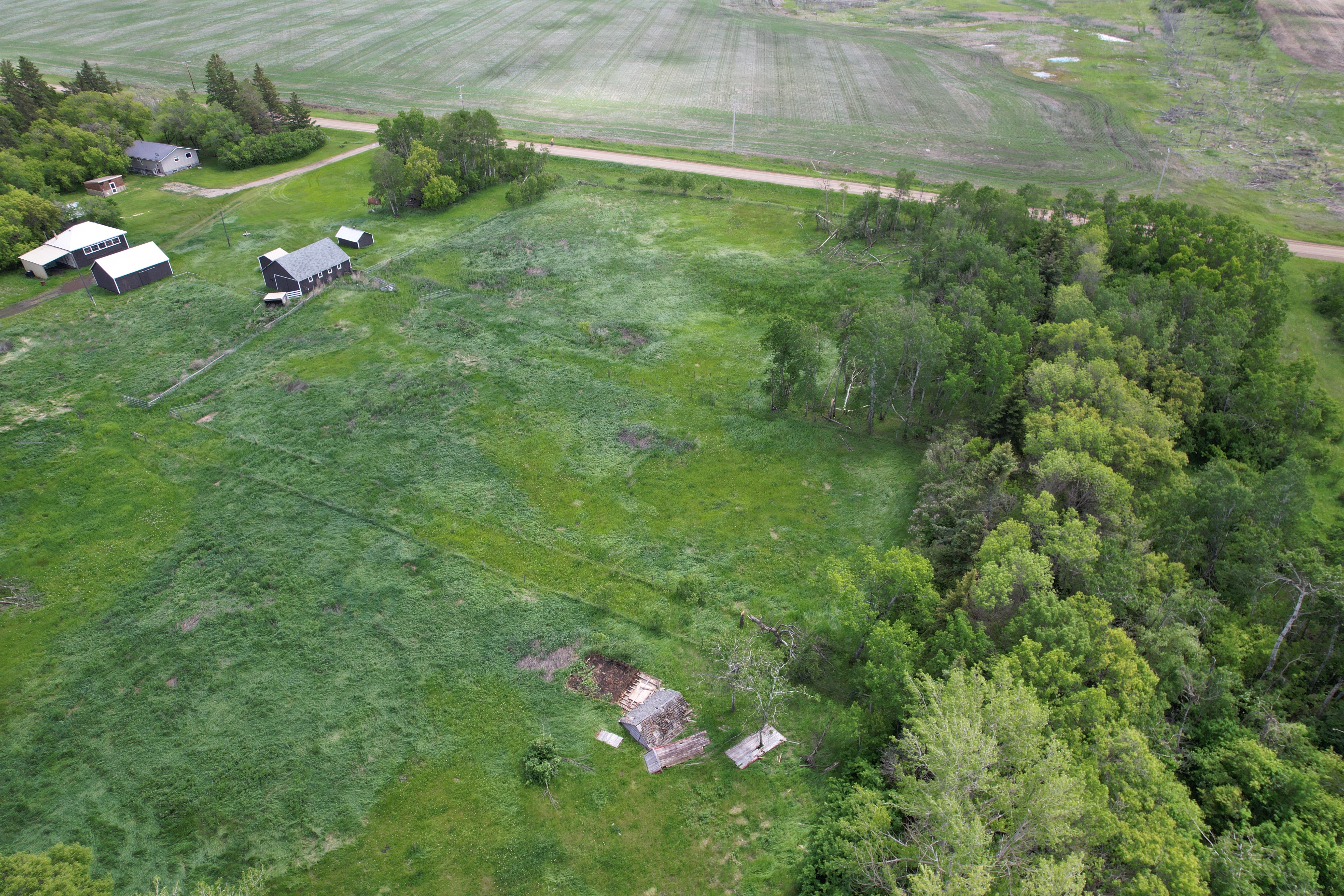
Drone image showing damage caused by tornado at Saltcoats, SK.
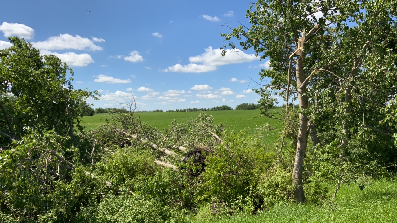
Ground photo of tree damage caused by the second Rivers, MB tornado.
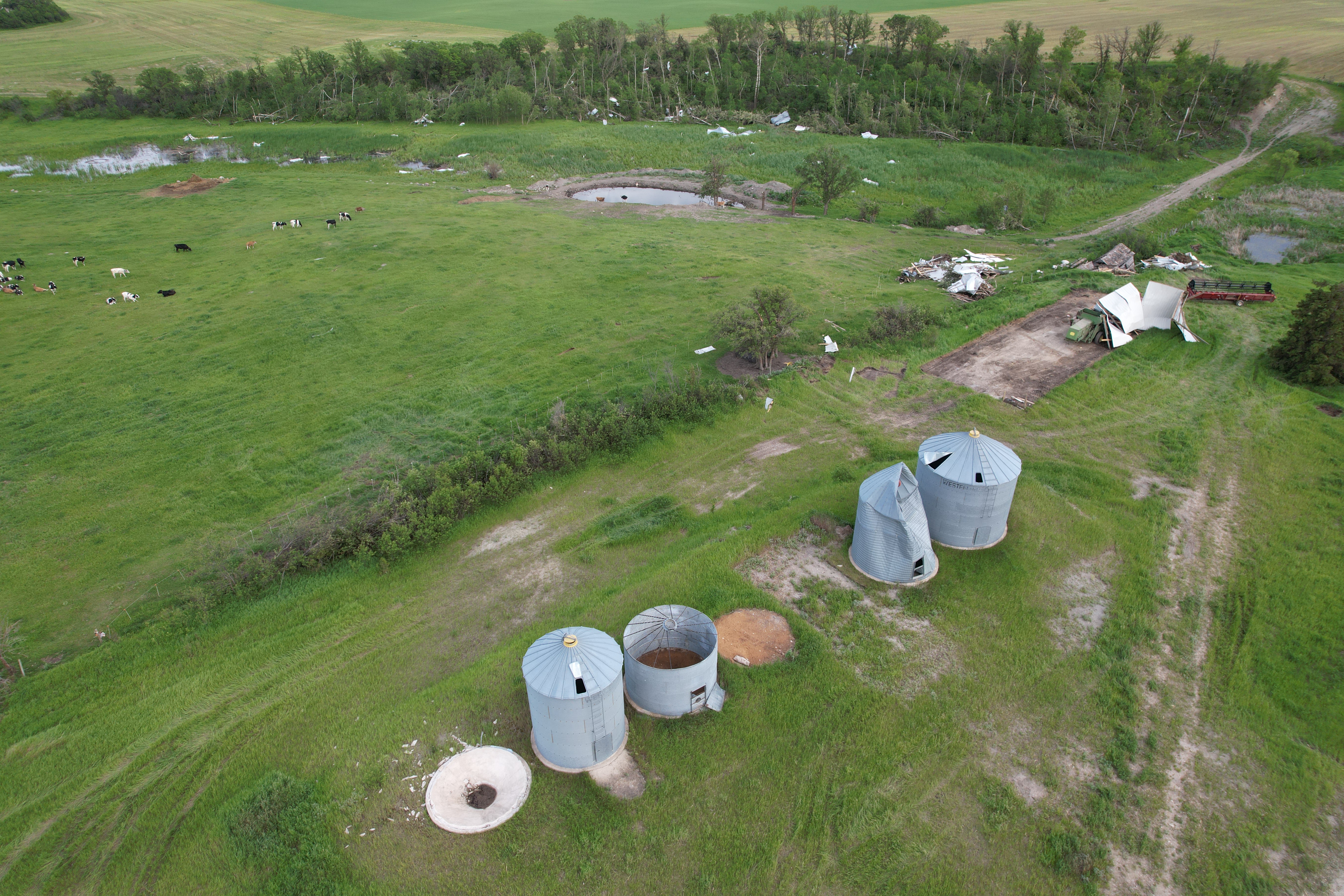
Drone image showing outbuilding, grain bin and tree damage caused by the second St. Alphonse, MB tornado.