Big update to 2024 tornadoes
This first NTP blog post for 2025 will provide information for 18 tornadoes in 2024 that had not been published here last year.
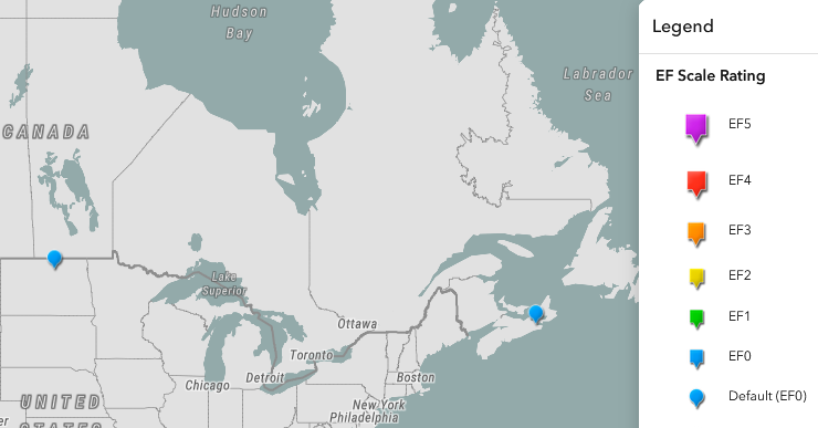
Two EF0-Default tornadoes - one in MB and one in NS - were confirmed well after they occurred. They had been included on the NTP Dashboard and in the 2024 tornado count, but until now had not appeared in a blog post.
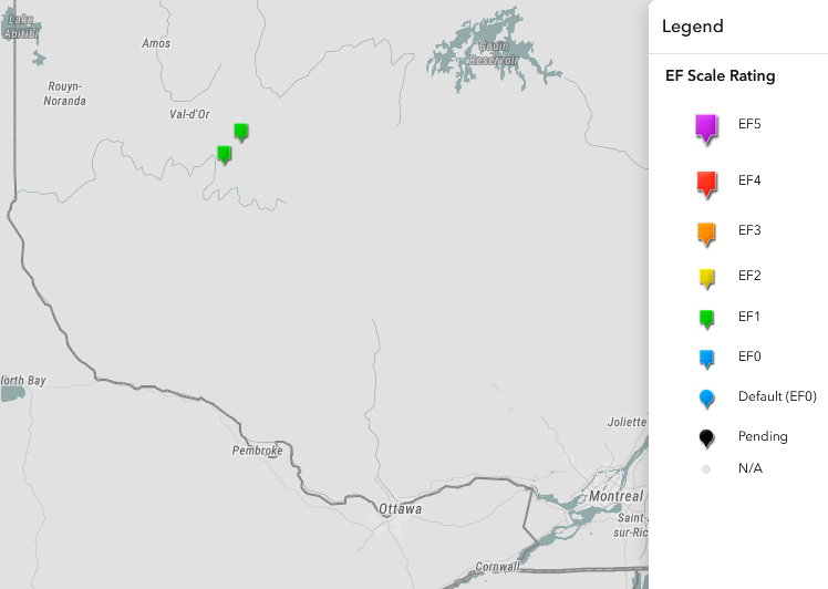
Two EF1 tornadoes - both in QC - were investigated earlier in the summer but are only now being confirmed and added to the Dashboard.
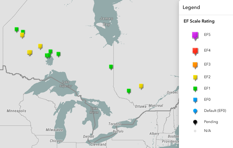
The remaining 14 tornadoes are the result of a systematic satellite imagery review of millions of squared kilometres of the country that we undertake at the end of each season to ensure we didn't miss any events. These events occurred mainly in ON and QC, though there is one from AB as well. The ratings on these are all either EF1 or EF2, given that satellite-detected wind damage in forested areas in not typically rated below EF1 or above EF2.
All of the newly confirmed tornadoes take the 2024 tornado count to 129 - quite a busy year!
Full details are provided in the event summaries and regional maps below, in the order presented in the discussion above. These tornadoes can be plotted via the NTP Dashboard here: https://westernu.maps.arcgis.com/apps/dashboards/19460b79cf24493680e5792f5247f46d
====
Event Name: Wakopa, MB
Date: June 22, 2022
Start Time: 4:15 PM CDT (2115 UTC)
Final Classification: Tornado (Over Land)
Final EF-Scale Rating: EF0-Default
Estimated tornado location: 49.07N, 99.78W
Description: Witness captured a photo of a tornado in the Wakopa area (and additional video of the funnel cloud was also captured). As no damage was reported and satellite imagery review revealed no visible damage, the EF-scale assessment is default EF0. Information available insufficient to accurately estimate track length, max. path width and tornado motion. Start time is based on witness report.
Event Name: Gulf of St. Lawrence (Mabou Mines), NS
Date: July 26, 2024
Estimated Start Time: 3:00 PM ADT (1800 UTC)
Final Classification: Tornado (Over Water)
Final EF-Scale Rating: EF0-Default
Estimated Tornado Location: 46.12N, 61.50W
Description: Witness near Mabou Mines (Cape Breton Island) captured a photo of a waterspout over the Gulf of St. Lawrence. No damage was reported. Event time is radar estimated.

Map showing the locations of the two tornadoes already included in the tornado count (of 113).
===
Event Name: Lac Cooper (Val-d’Or), QC
Date: June 13, 2024
Start Time: 5:55 PM EDT (2155 UTC)
Final Classification: Tornado (over land)
Final EF-Scale Rating: EF1
EF-Scale Damage Indicator / Degree of Damage: C-T/DOD-5
Start of damage track: 47.9039N, 77.2797W
End of damage track: 47.9057N, 77.2561W
Location of worst damage: 47.9041N, 77.2713W
Description: Satellite imagery review of a storm track of interest revealed tornado damage in forested areas near Lac Cooper (Val-d’Or). Damage assessed as EF1, with an estimated max. wind speed of 145 km/h, track length of 1.78 km and max. path width of 120 m. Tornado motion was from the W (approx. 265 degrees). Start time is radar estimated.
Event Name: Lac Granet (Val-d’Or), QC
Date: June 13, 2024
Start Time: 6:35 PM EDT (2235 UTC)
Final Classification: Tornado (over land)
Final EF-Scale Rating: EF1
EF-Scale Damage Indicator / Degree of Damage: C-T/DOD-5
Start of damage track: 47.7545N, 77.4470W
End of damage track: 47.7485N, 77.4039W
Location of worst damage: 47.7498N, 77.4162W
Description: Satellite imagery review revealed visible tree damage in forested areas near Lac Bend and Lac Granet (Val-d’Or). An NTP survey team visited the area on June 26, 2024, identifying two areas of tornado damage along with some downburst damage. The tornado damage east of Lac Granet is assessed as EF1, with an estimated max. wind speed of 145 km/h, track length of 3.31 km and max. path width of 290 m. Tornado motion was from the W (approx. 280 degrees). Start time is radar estimated. Tornado damage further west near Lac Bend was assessed as EF2.

Map showing the locations of the two newly confirmed tornadoes investigated during the 2024 season in QC.
===
Event Name: Davies Lake (Wabakimi PP), ON
Date: May 18, 2024
Start Time: 6:45 PM EDT (2245 UTC)
Final Classification: Tornado (over land)
Final EF-Scale Rating: EF2
EF-Scale Damage Indicator / Degree of Damage: C-T/DOD-6
Start of damage track: 50.9043N, 89.9110W
End of damage track: 50.9122N, 89.8833W
Location of worst damage: 50.9086N, 89.8966W
Description: Satellite imagery review revealed a tornado damage path in forested areas near Davies Lake (in Wabakimi Provincial Park). Tornado damage assessed as EF2, with an estimated max. wind speed of 190 km/h, track length of 2.17 km and max. path width of 390 m. Tornado motion was from the WSW (approx. 245 degrees). Start time is radar estimated.
Event Name: Lac Chassé (Antoine-Labelle), QC
Date: June 13, 2024
Start Time: 9:00 PM EDT (0100 UTC)
Final Classification: Tornado (over land)
Final EF-Scale Rating: EF2
EF-Scale Damage Indicator / Degree of Damage: C-T/DOD-6
Start of damage track: 47.1886N, 75.6390W
End of damage track: 47.1859N, 75.5967W
Location of worst damage: 47.1864N, 75.6054W
Description: Satellite imagery review revealed tornado and downburst damage in forested areas near Lac Chassé (Antoine-Labelle). Tornado damage assessed as EF2, with an estimated max. wind speed of 190 km/h, track length of 3.26 km and max. path width of 380 m. Tornado motion was from the W (approx. 275 degrees). Start time is radar estimated. Concurrent weak downburst damage was also visible.
Event Name: Lac Findlay (Pontiac), QC
Date: June 13, 2024
Start Time: 9:15 PM EDT (0115Z)
Final Classification: Tornado (over land)
Final EF-Scale Rating: EF1
EF-Scale Damage Indicator / Degree of Damage: C-T/DOD-5
Start of damage track: 46.6000N, 77.3804W
End of damage track: 46.5854N, 77.3365W
Location of worst damage: 46.5998N, 77.3736W
Description: Satellite imagery review revealed tornado damage in forested areas near Lac Findlay (Pontiac). Damage assessed as EF1, with an estimated max. wind speed of 145 km/h, track length of 3.79 km and max. path width of 310 m. Tornado motion was from the WNW (approx. 295 degrees). Start time is radar estimated.
Event Name: Tickner Lake, ON
Date: June 24, 2024
Start Time: 6:15 PM CDT (2315 UTC)
Final Classification: Tornado (over land)
Final EF-Scale Rating: EF1
EF-Scale Damage Indicator / Degree of Damage: C-T/DOD-5
Start of damage track: 52.2767N, 93.2529W
End of damage track: 52.2628N, 93.1819W
Location of worst damage: 52.2681N, 93.2123W
Description: Satellite imagery review revealed a tornado damage path in forested areas near Tickner Lake (west of MacDowell Lake). Tornado damage assessed as EF1, with an estimated max. wind speed of 145 km/h, track length of 5.12 km and max. path width of 400 m. Tornado motion was from the WNW (approx. 290 degrees). Start time is radar estimated.
Event Name: Eades, ON
Date: July 14, 2024
Start Time: 11:55 PM EDT (0355 UTC)
Final Classification: Tornado (over land)
Final EF-Scale Rating: EF1
EF-Scale Damage Indicator / Degree of Damage: C-T/DOD-5
Start of damage track: 48.9018N, 79.8962W
End of damage track: 48.8835N, 79.8758W
Location of worst damage: 48.8860N, 79.8777W
Description: Satellite imagery review revealed a tornado damage path in forested areas south of Eades. Tornado damage assessed as EF1, with an estimated max. wind speed of 145 km/h, track length of 2.54 km and max. path width of 130 m. Tornado motion was from the NW (approx. 325 degrees). Start time is radar estimated.
Event Name: Sutterby Lake, ON
Date: July 28, 2024
Start Time: 1:00 AM CDT (0600 UTC)
Final Classification: Tornado (over land)
Final EF-Scale Rating: EF2
EF-Scale Damage Indicator / Degree of Damage: C-T/DOD-6
Start of damage track: 51.8949N, 92.4645W
End of damage track: 51.9036N, 92.4359W
Location of worst damage: 51.9013N, 92.4408W
Description: Satellite imagery review revealed a tornado damage path in forested areas near Sutterby Lake (south of MacDowell Lake). Tornado damage assessed as EF2, with an estimated max. wind speed of 190 km/h, track length of 2.23 km and max. path width of 230 m. Tornado motion was from the WSW (approx. 245 degrees). Estimated time of event based on lightning activity.
Event Name: Tutu Lake, ON
Date: July 28, 2024
Start Time: 1:15 AM CDT (0615 UTC)
Final Classification: Tornado (over land)
Final EF-Scale Rating: EF1
EF-Scale Damage Indicator / Degree of Damage: C-T/DOD-5
Start of damage track: 52.0470N, 92.3595W
End of damage track: 52.0664N, 92.2994W
Location of worst damage: 52.0529N, 92.3396W
Description: Satellite imagery review revealed a tornado damage path in forested areas near Tutu Lake (southeast of MacDowell Lake). Tornado damage assessed as EF1, with an estimated max. wind speed of 145 km/h, track length of 4.65 km and max. path width of 230 m. Tornado motion was from the WSW (approx. 240 degrees). Estimated time of event based on lightning activity.
Event Name: Aber Lake, ON
Date: July 28, 2024
Start Time: 9:30 AM CDT (1430 UTC)
Final Classification: Tornado (over land)
Final EF-Scale Rating: EF2
EF-Scale Damage Indicator / Degree of Damage: C-T/DOD-6
Start of damage track: 50.3349N, 91.4634W
End of damage track: 50.3515N, 91.3710W
Location of worst damage: 50.3470N, 91.3889W
Description: Satellite imagery review revealed a tornado damage path in forested areas near Aber Lake (northeast of Sioux Lookout). Tornado damage assessed as EF2, with an estimated max. wind speed of 190 km/h, track length of 6.89 km and max. path width of 460 m. Tornado motion was from the WSW (approx. 255 degrees). Start time is radar estimated.
Event Name: Rapid Lake, ON
Date: July 28, 2024
Start Time: 9:40 AM CDT (1440 UTC)
Final Classification: Tornado (over land)
Final EF-Scale Rating: EF2
EF-Scale Damage Indicator / Degree of Damage: C-T/DOD-6
Start of damage track: 50.3457N, 91.3475W
End of damage track: 50.3594N, 91.3199W
Location of worst damage: 50.3538N, 91.3313W
Description: Satellite imagery review revealed a tornado damage path in forested areas near Rapid Lake (northeast of Sioux Lookout). Tornado damage assessed as EF2, with an estimated max. wind speed of 190 km/h, track length of 2.50 km and max. path width of 220 m. Tornado motion was from the SW (approx. 230 degrees). Start time is radar estimated.
Event Name: Vooges Lake, ON
Date: July 28, 2024
Start Time: 2:00 PM EDT (1800 UTC)
Final Classification: Tornado (over land)
Final EF-Scale Rating: EF1
EF-Scale Damage Indicator / Degree of Damage: C-T/DOD-5
Start of damage track: 49.9477N, 88.9715W
End of damage track: 49.9410N, 88.9225W
Location of worst damage: 49.9458N, 88.9574W
Description: Satellite imagery review revealed a tornado damage path in forested areas near Vooges Lake (west of Lake Nipigon). Tornado damage assessed as EF1, with an estimated max. wind speed of 145 km/h, track length of 3.59 km and max. path width of 210 m. Tornado motion was from the W (approx. 280 degrees). Start time is radar estimated.
Event Name: Bell Island (Lake Nipigon), ON
Date: July 28, 2024
Start Time: 2:15 PM EDT (1815 UTC)
Final Classification: Tornado (over land)
Final EF-Scale Rating: EF1
EF-Scale Damage Indicator / Degree of Damage: C-T/DOD-5
Start of damage track: 49.9612N, 88.6887W
End of damage track: 49.9584N, 88.6684W
Location of worst damage: 49.9587N, 88.6746W
Description: Satellite imagery review revealed a tornado damage path in forested areas on Bell Island (Lake Nipigon). Tornado damage assessed as EF1, with an estimated max. wind speed of 145 km/h, track length of 1.50 km and max. path width of 300 m. Tornado motion was from the WNW (approx. 285 degrees). Start time is radar estimated.
Event Name: Ferland, ON
Date: July 28, 2024
Start Time: 2:30 PM EDT (1830 UTC)
Final Classification: Tornado (over land)
Final EF-Scale Rating: EF1
EF-Scale Damage Indicator / Degree of Damage: C-T/DOD-5
Start of damage track: 50.3038N, 88.4592W
End of damage track: 50.3067N, 88.4065W
Location of worst damage: 50.3054N, 88.4518W
Description: Satellite imagery review revealed a tornado damage path in forested areas near Ferland (north of Lake Nipigon). Tornado damage assessed as EF1, with an estimated max. wind speed of 145 km/h, track length of 3.79 km and max. path width of 220 m. Tornado motion was from the W (approx. 265 degrees). Start time is radar estimated.
Event Name: Suni Lake, ON
Date: July 28, 2024
Start Time: 3:30 PM EDT (1930 UTC)
Final Classification: Tornado (over land)
Final EF-Scale Rating: EF1
EF-Scale Damage Indicator / Degree of Damage: C-T/DOD-5
Start of damage track: 50.0798N, 87.3343W
End of damage track: 50.0902N, 87.2200W
Location of worst damage: 50.0887N, 87.2563W
Description: Satellite imagery review revealed a tornado damage path in forested areas near Suni Lake (east of Lake Nipigon). Tornado damage assessed as EF1, with an estimated max. wind speed of 170 km/h, track length of 8.30 km and max. path width of 350 m. Tornado motion was from the W (approx. 260 degrees). Start time is radar estimated.
Map showing the 13 tornadoes in ON and QC found via the systematic satellite review.
===
Event Name: Piché Lake, AB
Date: July 31, 2024
Start Time: 6:25 PM MDT (0025 UTC)
Final Classification: Tornado (over land)
Final EF-Scale Rating: EF1
EF-Scale Damage Indicator / Degree of Damage: C-T/DOD-5
Start of damage track: 55.0265N, 111.6685W
End of damage track: 55.0255N, 111.6164W
Location of worst damage: 55.0253N, 111.6542W
Description: Satellite imagery review revealed a tornado damage path in forested areas near Piché Lake (northeast of Imperial Mills). Tornado damage assessed as EF1, with an estimated max. wind speed of 145 km/h, track length of 3.36 km and max. path width of 430 m. Tornado motion was from the W (approx. 270 degrees). Start time is radar estimated.

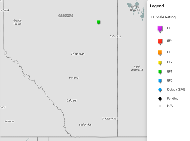
Map showing the location of the AB EF1 tornado found during systematic satellite imagery review.
