Nine new QC tornadoes based on AI-assisted satellite review
The NTP has confirmed nine new Quebec tornadoes for 2025 based on our end-of-season satellite review, in this case assisted by an AI detection algorithm. The damage in each case was only to trees, with one tornado rated EF2 and eight rated EF1.
Details are provided below via event summaries and a regional map. The tornadoes can be plotted using the NTP Dashboard here.
====
Event Name: Lac la Tour (La Tuque), QC
Date: April 29, 2025
Start Time: 7:30 PM EDT (2330 UTC)
Final Classification: Tornado (over land)
Final EF-Scale Rating: EF1
EF-Scale Damage Indicator / Degree of Damage: C-T/DOD-5
Start of damage track: 47.1376N, 73.0523W
End of damage track: 47.1372N, 73.0139W
Location of worst damage: 47.1371N, 73.0448W
Description: AI-assisted satellite imagery review identified a tornado damage path in forested areas at Lac la Tour (southwest of La Tuque). Tornado damage assessed as EF1, with an estimated max. wind speed of 145 km/h, track length of 2.93 km and max. path width of 240 m. Tornado motion was from the W (approx. 270 degrees). Start time is radar estimated.
Event Name: Lac Kamishakamatsh (Maria-Chapdelaine), QC
Date: June 10, 2025
Start Time: 3:40 PM EDT (1940 UTC)
Final Classification: Tornado (over land)
Final EF-Scale Rating: EF2
EF-Scale Damage Indicator / Degree of Damage: C-T/DOD-6
Start of damage track: 49.5758N, 72.6020W
End of damage track: 49.6053N, 72.5824W
Location of worst damage: 49.5916N, 72.5940W
Description: AI-assisted satellite imagery review identified a tornado damage path in forested areas near Lac Kamishakamatsh (northwest of Saguenay). Tornado damage assessed as EF2, with an estimated max. wind speed of 190 km/h, track length of 3.63 km and max. path width of 280 m. Tornado motion was from the SSW (approx. 205 degrees). Start time is radar estimated.
Event Name: Saint-Marcel, QC
Date: June 19, 2025
Start Time: 7:20 PM EDT (2320 UTC)
Final Classification: Tornado (over land)
Final EF-Scale Rating: EF1
EF-Scale Damage Indicator / Degree of Damage: C-T/DOD-5
Start of damage track: 46.8705N, 70.1242W
End of damage track: 46.8765N, 70.1103W
Location of worst damage: 46.8715N, 70.1229W
Description: AI-assisted satellite imagery review identified a tornado damage path in forested areas southwest of Saint-Marcel. Tornado damage assessed as EF1, with an estimated max. wind speed of 145 km/h, track length of 1.28 km and max. path width of 160 m. Tornado motion was from the WSW (approx. 240 degrees). Start time is radar estimated.
Event Name: Lac Garni de Bois (La Tuque), QC
Date: June 23, 2025
Start Time: 6:30 PM EDT (2230 UTC)
Final Classification: Tornado (over land)
Final EF-Scale Rating: EF1
EF-Scale Damage Indicator / Degree of Damage: C-T/DOD-5
Start of damage track: 48.2033N, 73.5234W
End of damage track: 48.2098N, 73.4927W
Location of worst damage: 48.2066N, 73.5026W
Description: AI-assisted satellite imagery review identified a tornado damage path in forested areas near Lac Garni de Bois (northeast of Wemotaci). Tornado damage assessed as EF1, with an estimated max. wind speed of 145 km/h, track length of 2.42 km and max. path width of 170 m. Tornado motion was from the WSW (approx. 255 degrees). Start time is radar estimated.
Event Name: Lac Vassal (Abitibi), QC
Date: July 5, 2025
Start Time: 5:40 PM EDT (2140 UTC)
Final Classification: Tornado (over land)
Final EF-Scale Rating: EF1
EF-Scale Damage Indicator / Degree of Damage: C-T/DOD-5
Start of damage track: 48.8188N, 77.7255W
End of damage track: 48.8201N, 77.6667W
Location of worst damage: 48.8186N, 77.7237W
Description: AI-assisted satellite imagery review identified a tornado damage path in forested areas near Lac Vassal (northeast of Amos). Tornado damage assessed as EF1, with an estimated max. wind speed of 145 km/h, track length of 4.35 km and max. path width of 140 m. Tornado motion was from the W (approx. 270 degrees). Start time is radar estimated.
Event Name: Lac de la Rencontre (La Tuque), QC
Date: July 5, 2025
Start Time: 8:10 PM EDT (0010 UTC)
Final Classification: Tornado (over land)
Final EF-Scale Rating: EF1
EF-Scale Damage Indicator / Degree of Damage: C-T/DOD-5
Start of damage track: 48.7270N, 75.1821W
End of damage track: 48.7285N, 75.1371W
Location of worst damage: 48.7270N, 75.1633W
Description: AI-assisted satellite imagery review identified a tornado damage path in forested areas near Lac de la Rencontre (northwest of Obedjiwan). Tornado damage assessed as EF1, with an estimated max. wind speed of 145 km/h, track length of 3.32 km and max. path width of 140 m. Tornado motion was from the W (approx. 265 degrees). Start time is radar estimated.
Event Name: Fugèreville, QC
Date: July 12, 2025
Start Time: 8:25 PM EDT (0025 UTC)
Final Classification: Tornado (over land)
Final EF-Scale Rating: EF1
EF-Scale Damage Indicator / Degree of Damage: C-T/DOD-5
Start of damage track: 47.4361N, 79.1574W
End of damage track: 47.4473N, 79.1528W
Location of worst damage: 47.4433N, 79.1554W
Description: AI-assisted satellite imagery review identified a tornado damage path in forested areas northeast of Fugèreville. Tornado damage assessed as EF1, with an estimated max. wind speed of 145 km/h, track length of 1.30 km and max. path width of 90 m. Tornado motion was from the SSW (approx. 195 degrees). Start time is radar estimated.
Event Name: Lac Earley (Pontiac), QC
Date: July 17, 2025
Start Time: 12:30 PM EDT (1630 UTC)
Final Classification: Tornado (over land)
Final EF-Scale Rating: EF1
EF-Scale Damage Indicator / Degree of Damage: C-T/DOD-5
Start of damage track: 45.9856N, 76.2844W
End of damage track: 45.9970N, 76.2560W
Location of worst damage: 45.9940N, 76.2649W
Description: AI-assisted satellite imagery review identified a tornado damage path in forested areas near Lac Earley (northeast of Otter Lake). Tornado damage assessed as EF1, with an estimated max. wind speed of 145 km/h, track length of 2.58 km and max. path width of 320 m. Tornado motion was from the WSW (approx. 240 degrees). Start time is radar estimated.
Event Name: Lac François (Côte-de-Beaupré), QC
Date: August 3, 2025
Start Time: 5:05 PM EDT (2105 UTC)
Final Classification: Tornado (over land)
Final EF-Scale Rating: EF1
EF-Scale Damage Indicator / Degree of Damage: C-T/DOD-5
Start of damage track: 47.7388N, 71.4704W
End of damage track: 47.7217N, 71.3999W
Location of worst damage: 47.7365N, 71.4500W
Description: AI-assisted satellite imagery review identified a tornado damage path in forested areas near Lac François (northwest of L'Etape). Tornado damage assessed as EF1, with an estimated max. wind speed of 145 km/h, track length of 5.73 km and max. path width of 310 m. Tornado motion was from the WNW (approx. 290 degrees). Start time is radar estimated.
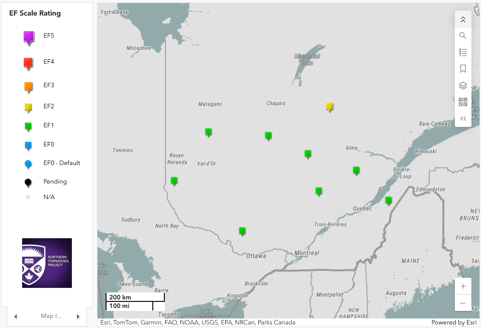
Regional map showing the locations of the nine new tornadoes for 2025 in Quebec.