Tornado update for Northern Ontario
After thorough investigation, the NTP can provide a tornado update for Northern Ontario: three new tornadoes and a downburst rating upgrade. The new tornadoes include an EF2 tornado and an EF1 tornado in northwestern Ontario (near Thunder Bay and Ignace, respectively), and an EF1 tornado in northeastern Ontario (near Chapleau).
The damage rating for the June 21 downburst that affected Samuel de Champlain Provincial Park near Mattawa has also been upgraded from EF1 to EF2, with a maximum wind speed of 190 km/h.
More details are provided in the event summaries below, along with a regional map for the tornadoes as well as satellite imagery showing the damage. The tornadoes can also be plotted on a map using the NTP Dashboad here.
====
Event Name: Wapageisi Lake, ON
Date: July 22, 2025
Start Time: 8:40 PM CDT (0140 UTC)
Final Classification: Tornado (Over Land)
Final EF-Scale Rating: EF1
EF-Scale Damage Indicator / Degree of Damage: C-T/DOD-5
Start of damage track: 49.3294N, 92.3230W
End of damage track: 49.3279N, 92.3086W
Location of worst damage: 49.3286N, 92.3147W
Description: Satellite imagery review of a storm track of interest revealed a tornado damage path through forested areas at Wapageisi Lake (west of Ignace). Damage assessed as EF1 tornado, with an estimated max. wind speed of 145 km/h, track length of 1.07 km and max. path width of 180 m. Tornado motion was from the W (approx. 280 degrees). Start time is radar estimated. An area of unclassified wind damage north of Beak Lake was also visible east of this tornado track.
Event Name: Swallow Lake (Thunder Bay), ON
Date: July 26, 2025
Start Time: 3:55 PM EDT (1955 UTC)
Final Classification: Tornado (Over Land)
Final EF-Scale Rating: EF2
EF-Scale Damage Indicator / Degree of Damage: C-T/DOD-6
Start of damage track: 48.4105N, 90.3730W
End of damage track: 48.4435N, 90.2790W
Location of worst damage: 48.4332N, 90.3200W
Description: Satellite imagery review of a storm track of interest revealed a tornado damage path through forested areas near Swallow Lake (west of Thunder Bay). Damage assessed as EF2 tornado, with an estimated max. wind speed of 190 km/h, track length of 7.99 km and max. path width of 400 m. Tornado motion was from the WSW (approx. 240 degrees). Start time is radar estimated.
Event Name: Oscar Lake (Chapleau), ON
Date: July 28, 2025
Start Time: 3:35 AM EDT (0735 UTC)
Final Classification: Tornado (Over Land)
Final EF-Scale Rating: EF1
EF-Scale Damage Indicator / Degree of Damage: C-T/DOD-5
Start of damage track: 47.9528N, 82.9993W
End of damage track: 47.9522N, 82.9529W
Location of worst damage: 47.9524N, 82.9715W
Description: Satellite imagery review revealed a tornado damage path through forested areas near Oscar Lake (northeast of Chapleau). Damage assessed as EF1 tornado, with an estimated max. wind speed of 145 km/h, track length of 3.50 km and max. path width of 210 m. Tornado motion was from the W (approx. 270 degrees). Start time is radar estimated. The parent storm later produced a second tornado further east near Hellyer Lake.
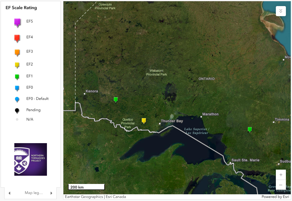
Regional map showing the locations and ratings for the three new tornadoes in Northern Ontario.
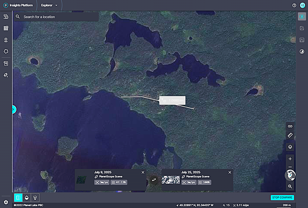
Planet.com satellite image showing the tree damage from the Wapageisi Lake EF1 tornado with length measurement superimposed.
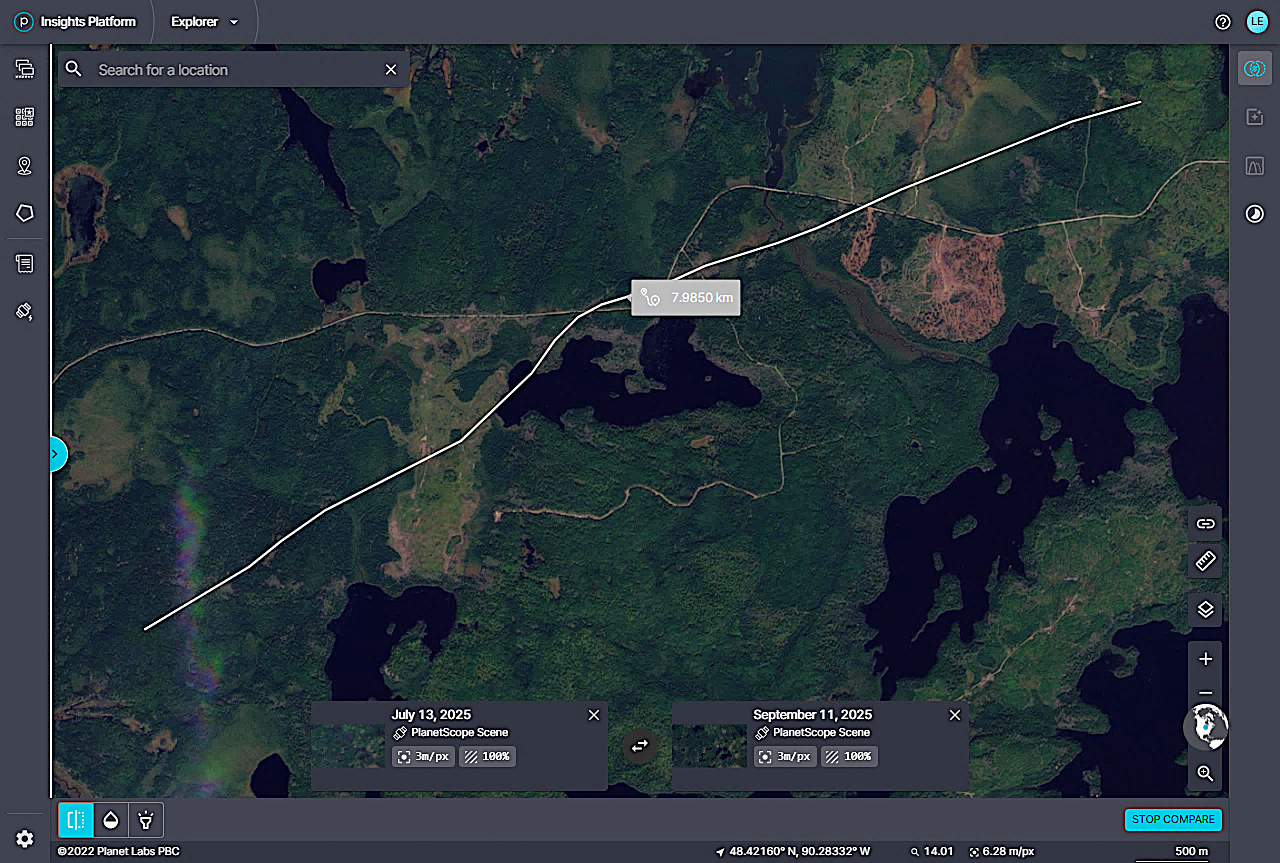
Planet.com satellite image showing the tree damage from the Swallow Lake EF2 tornado with length measurement superimposed.
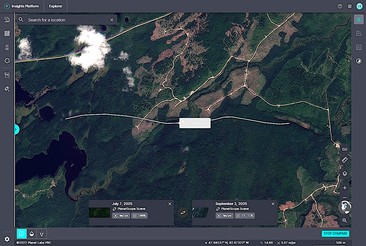
Planet.com satellite image showing intermittent tree damage from the Oscar Lake EF1 tornado with length measurement superimposed.