Sites
The micro-pulse lidars at each site are part of MPLNET . Sites also have co-located, or closely located, CIMEL sunphotometers which are part of AERONET . Each site has a Purple Air sensor, which are included as part of Environment and Climate Change Canada’s Hourly PM 2.5 Air Quality map .
CAMBRIDGE BAY
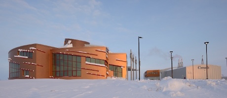 The Cambridge Bay MPL is also a part of the Multidisciplinary Observatory for Arctic Climate Change and Extreme Events Monitoring (MOACC) project, led by the Université de Sherbrooke. The main objective of the MOACC project is to develop and maintain a long-term measurement observatory for monitoring the impact of climate change and winter extreme events (WEEs) in the Arctic, as well as key atmospheric radiative forcing constituents such as greenhouse gases (GHGs), aerosols, and clouds. The MPL is located at the Canadian High Arctic Research Station (CHARS).
EUREKA
 The Eureka Weather Station was established in 1947. It is now operated by Environment and Climate Change Canada (ECCC) . A University consortium called the Canadian Network for the Detection of Atmospheric Change (CANDAC) operates three additional facilities at Eureka, including the Polar Environment Atmospheric Research Laboratory (PEARL), the Ridge Laboratory (located approximately 15 km by road from Eureka at 600 m elevation), and The Zero Altitude PEARL Auxiliary Laboratory (0PAL) located just north of Eureka. PEARL has over 20 instruments, most in near-continuous operation, including a CIMEL sun photometer, a star photometer and the CANDAC Rayleigh-Mie-Raman Lidar. The MPLCAN instrument will allow 24/7 lidar measurements, and will be installed at 0PAL in Summer, 2021.
HALIFAX
 The Nova Scotia node is situated on the Atlantic Ocean at the National Research Council marine research station in Sandy Cove, about 25 km south of Halifax. The site is marine, urban, and also surrounded by mixed Acadian forests. Halifax is the largest population center (~300,000 people) within a 600 km radius, complemented by upwind NAPS stations in western (rural) Nova Scotia, which enables trans-boundary pollution transport studies (Mitchell et al., 2021, in press). Also of great interest at this node is the marine influence on atmospheric processes involving trace gases and aerosols, e.g., air-sea exchange and fog formation.
The mMPL is located at the Saint Mary's University Atmospheric Observatory (SAO) established in 2019, which also operates an open-path FTIR spectrometer that measures a broad suite of air quality and climate change gases (Wiacek et al., 2018), a Davis Vantage Pro weather station (p, T, RH, wind, UV, irradiance), an Airpointer (O3, CO, NOx, SO2, PM2.5) and a Purple Air PM2.5 sensor. The Dalhousie University campus is located 1.2 km away and hosts a remote sensing AERONET network sunphotometer (in operation since 2002), as well as a node of the SPARTAN network (surface particulate matter, established in 2012). [mMPL installation is planned for the summer of 2021.]
LONDON
 The London, Ontario node is located on the campus of The University of Western Ontario. In addition to the MPL the site contains a CIMEL sun photometer, a Lufft CHM 15K ceilometer and a PurpleAir PM2.5 sensor. London is situated in Southern Ontario approximately halfway between the large urban areas of Toronto, Detroit, and Cleveland, which can affect its local air quality. Of particular interest to the London site is the tracking of particulates which change the air quality both surface and aloft.
The ceilometer at the London site is part of the E-PROFILE network.
SASKATOON
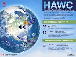 HAWC (High-altitude Aerosols, Water Vapour and Clouds) is a planned Canadian mission that will provide critical data to support severe and extreme weather prediction, climate modelling, air quality forecasting, and monitoring of disasters, such as volcanic eruptions, wildfires, and extreme precipitation. The University of Saskatoon will be developing two of the HAWC instruments. MPLCAN will be an important complement to the space-based measurements.
SHERBROOKE
 The Sherbrooke MPLCAN site is located at the Mont Bellevue SIRENE station on the Université de Sherbrooke campus. The instrument suite includes an MPL, a CIMEL sunphotometer / sky radiometer / moonphotometer, an SPS starphotometer, a 2nd polarization-sensitive CIMEL instrument, a PurpleAir PM2.5 sensor, SPARTAN PM2.5 / PM10 sensors as well as a SPARTAN 3 λ nephelometer. Air quality is affected by the regional pollution of the Toronto – Montréal corridor and the local pollution of Montreal and the Sherbrooke environs. A key Sherbrooke research interest is to exploit the instrument suite in order to provide the means of transforming satellite multi-band images to regional pollution index maps that are relevant to the health community.
STONY PLAIN
-
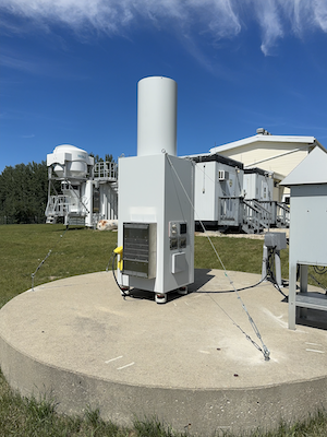
Environment and Climate Change Canada is the lead federal department for a wide range of environmental issues, focusing on minimizing threats to Canadians and their environment from pollution; equipping Canadians to make informed decisions on weather, water, and climate conditions; and conserving and restoring Canada's natural environment. The Stony Plain meteorological site, located about 40 min west of Edmonton, hosts a wide range of atmospheric instrumentation, including an AEROCAN site. They also launch twice-daily radiosondings.
TORONTO
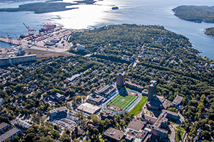
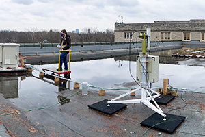
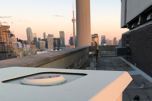 The Toronto, Ontario node is located on the St. George Campus of the University of Toronto in downtown Toronto. The MiniMPL is co-located with the well-equipped Toronto Atmospheric Observatory , a moderate-resolution Fourier transform spectrometer that measures atmospheric carbon dioxide, methane, and carbon monoxide, and a PurpleAir PM2.5 sensor. The MiniMPL in Toronto runs during daylight hours only.