First batch of tornadoes based on AI-assisted satellite review
A bit of history here - these five new NTP-confirmed tornadoes are the first batch to be initially identified via AI-assisted satellite review of tree damage in forested areas. The first area to be searched using the experimental tool was in Northern Ontario east of Lake Superior. The initial identifications were manually confirmed and documented. Four of the tornadoes (including an EF2) are from July 28, 2025 while the fifth is from August 16, 2025.
Details are provided in the event summaries below, along with a regional map and satellite images showing the tree damage identified. The tornadoes can be plotted on a map using the NTP Dashboard here.
====
Event Name: Whitefish Lake, ON
Date: July 28, 2025
Start Time: 1:25 AM EDT (0525 UTC)
Final Classification: Tornado (over land)
Final EF-Scale Rating: EF2
EF-Scale Damage Indicator / Degree of Damage: C-T/DOD-6
Start of damage track: 48.5210N, 85.3236W
End of damage track: 48.5600N, 85.2085W
Location of worst damage: 48.5449N, 85.2423W
Description: AI-assisted satellite imagery review identified a tornado damage path in forested areas near Whitefish Lake (south of White River). Tornado damage assessed as EF2, with an estimated max. wind speed of 190 km/h, track length of 9.61 km and max. path width of 670 m. Tornado motion was from the WSW (approx. 245 degrees). Start time is radar estimated.
Event Name: McMaster Lake, ON
Date: July 28, 2025
Start Time: 1:35 AM EDT (0535 UTC)
Final Classification: Tornado (over land)
Final EF-Scale Rating: EF1
EF-Scale Damage Indicator / Degree of Damage: C-T/DOD-5
Start of damage track: 48.3680N, 85.2455W
End of damage track: 48.3713N, 85.1819W
Location of worst damage: 48.3688N, 85.2355W
Description: AI-assisted satellite imagery review identified a tornado damage path in forested areas near McMaster Lake (south of White River). Tornado damage assessed as EF1, with an estimated max. wind speed of 145 km/h, track length of 4.77 km and max. path width of 510 m. Tornado motion was from the W (approx. 265 degrees). Start time is radar estimated.
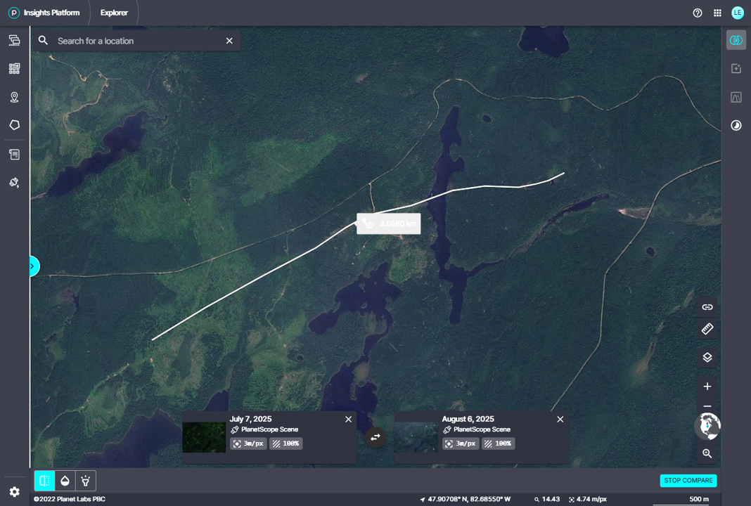
Event Name: Hellyer Lake, ON
Date: July 28, 2025
Start Time: 3:45 AM EDT (0745 UTC)
Final Classification: Tornado (over land)
Final EF-Scale Rating: EF1
EF-Scale Damage Indicator / Degree of Damage: C-T/DOD-5
Start of damage track: 47.9527N, 82.8970W
End of damage track: 47.9543N, 82.8021W
Location of worst damage: 47.9532N, 82.8278W
Description: AI-assisted satellite imagery review identified a tornado damage path in forested areas at Hellyer Lake (northeast of Chapleau). Tornado damage assessed as EF1, with an estimated max. wind speed of 145 km/h, track length of 7.16 km and max. path width of 350 m. Tornado motion was from the W (approx. 270 degrees). Start time is radar estimated. The same parent storm earlier produced the EF1 Oscar Lake tornado.
Event Name: Ridley Lake, ON
Date: July 28, 2025
Start Time: 3:55 AM EDT (0755 UTC)
Final Classification: Tornado (over land)
Final EF-Scale Rating: EF1
EF-Scale Damage Indicator / Degree of Damage: C-T/DOD-5
Start of damage track: 47.9090N, 82.7168W
End of damage track: 47.9225N, 82.6673W
Location of worst damage: 47.9190N, 82.6907W
Description: AI-assisted satellite imagery review identified a tornado damage path in forested areas near Ridley Lake (northeast of Chapleau). Tornado damage assessed as EF1, with an estimated max. wind speed of 145 km/h, track length of 4.06 km and max. path width of 250 m. Tornado motion was from the WSW (approx. 250 degrees). Start time is radar estimated.
Event Name: Abbott Lake, ON
Date: August 16, 2025
Start Time: 8:50 PM EDT (0050 UTC)
Final Classification: Tornado (over land)
Final EF-Scale Rating: EF1
EF-Scale Damage Indicator / Degree of Damage: C-T/DOD-5
Start of damage track: 46.7555N, 81.7176W
End of damage track: 46.7643N, 81.6549W
Location of worst damage: 46.7620N, 81.6865W
Description: AI-assisted satellite imagery review identified a tornado damage path in forested areas near Abbott Lake (northwest of Sudbury). Tornado damage assessed as EF1, with an estimated max. wind speed of 145 km/h, track length of 4.98 km and max. path width of 350 m. Tornado motion was from the W (approx. 260 degrees). Start time is radar estimated.
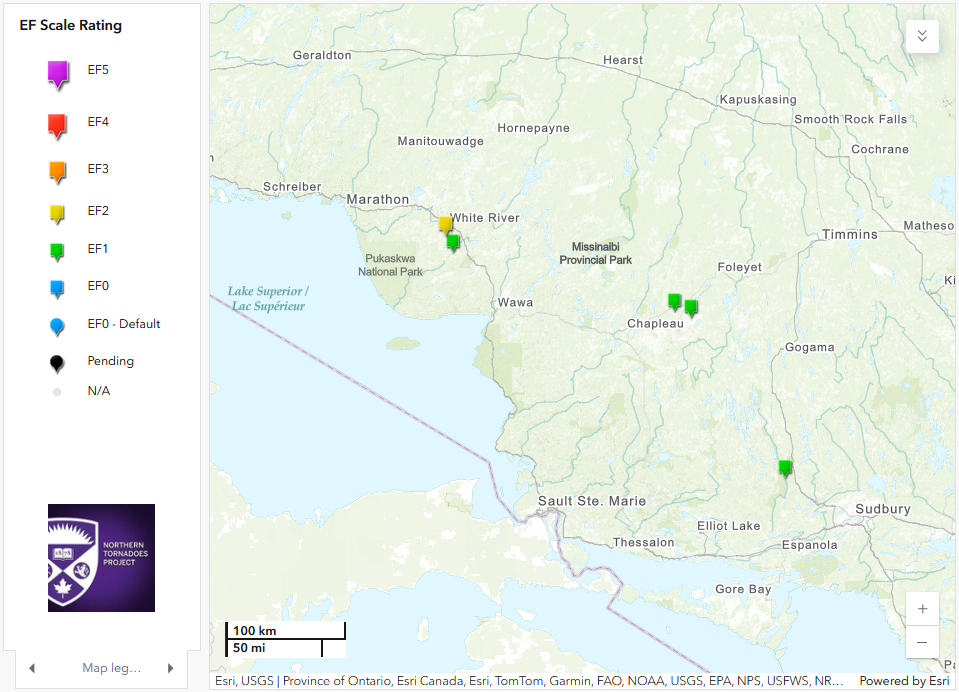
Regional map showing the location of the five new tornadoes confirmed through AI-assisted satellite review.
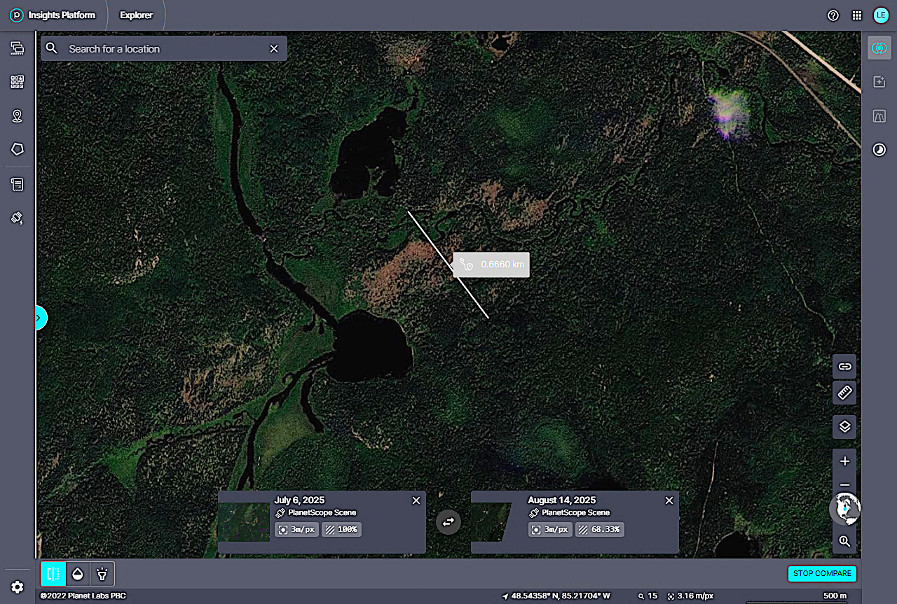
Planet.com satellite image showing EF2 tree damage at Whitefish Lake, ON with max width measurement superimposed.
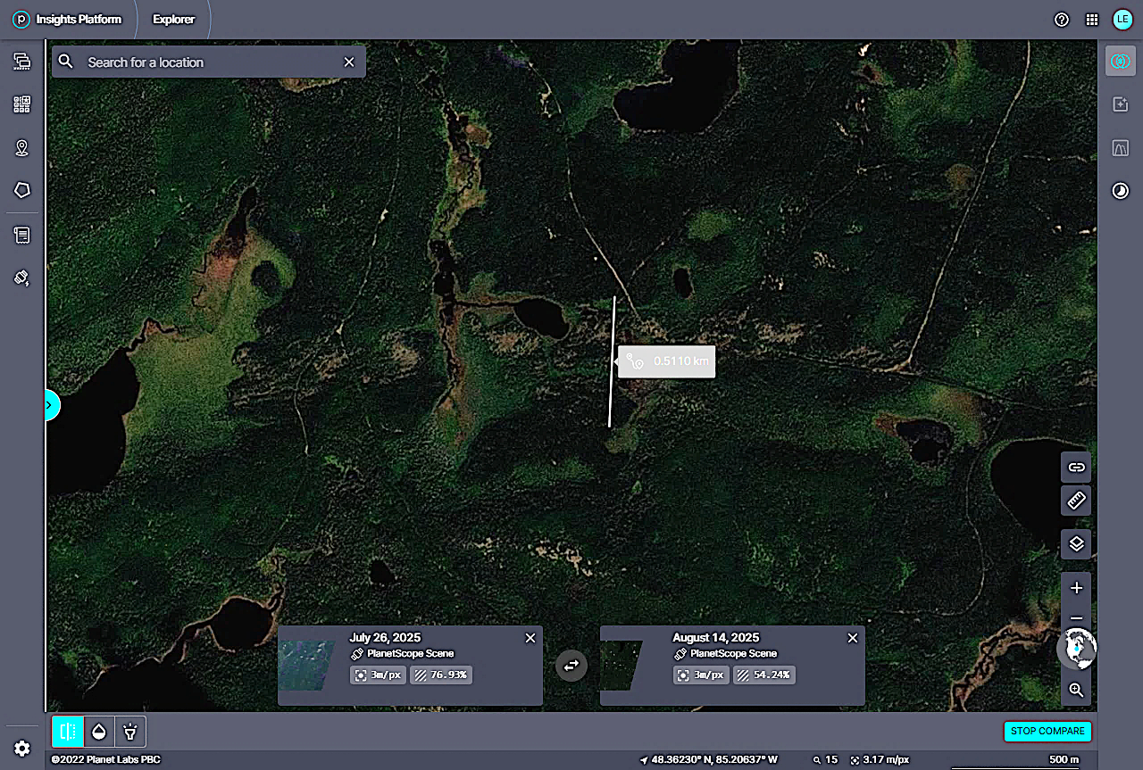
Planet.com satellite image showing EF1 tree damage at McMaster Lake, ON with max width measurement superimposed.
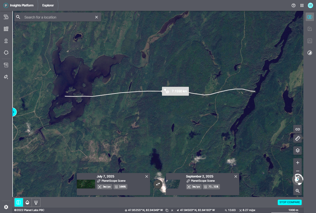
Planet.com satellite image showing EF1 tree damage at Hellyer Lake, ON with length measurement superimposed.
Planet.com satellite image showing EF1 tree damage at Ridley Lake, ON with length measurement superimposed.
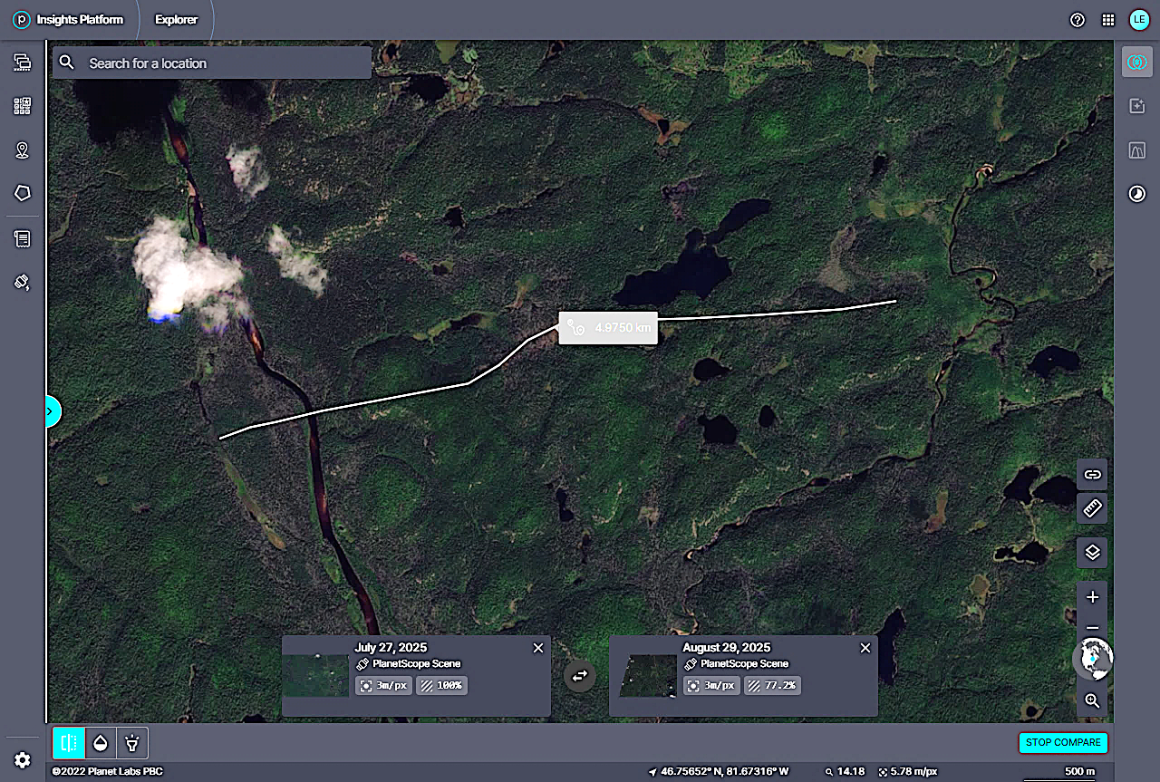
Planet.com satellite image showing EF1 tree damage at Abbott Lake, ON with length measurement superimposed.